

Markersdorf-Krumbach-Mittweida-Markersdorf
A cycling route starting in Claußnitz, Saxony, Germany.
Overview
About this route
Schöne Naturstrecke.
- -:--
- Duration
- 38.3 km
- Distance
- 398 m
- Ascent
- 372 m
- Descent
- ---
- Avg. speed
- 330 m
- Avg. speed
Route quality
Waytypes & surfaces along the route
Waytypes
Quiet road
13.4 km
(35 %)
Road
11.3 km
(29 %)
Surfaces
Paved
28.6 km
(75 %)
Unpaved
1.8 km
(5 %)
Asphalt
27 km
(70 %)
Paving stones
0.9 km
(2 %)
Continue with Bikemap
Use, edit, or download this cycling route
You would like to ride Markersdorf-Krumbach-Mittweida-Markersdorf or customize it for your own trip? Here is what you can do with this Bikemap route:
Free features
- Save this route as favorite or in collections
- Copy & plan your own version of this route
- Sync your route with Garmin or Wahoo
Premium features
Free trial for 3 days, or one-time payment. More about Bikemap Premium.
- Navigate this route on iOS & Android
- Export a GPX / KML file of this route
- Create your custom printout (try it for free)
- Download this route for offline navigation
Discover more Premium features.
Get Bikemap PremiumFrom our community
Other popular routes starting in Claußnitz
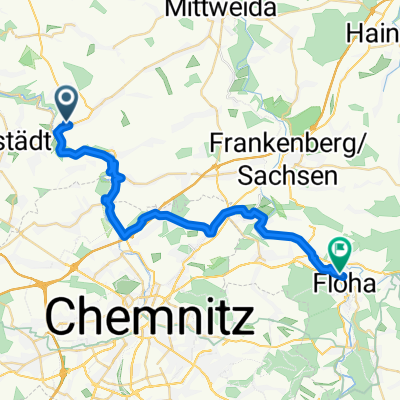 Markersdorf-Flöha
- Distance
- 29.5 km
- Ascent
- 222 m
- Descent
- 237 m
- Location
- Claußnitz, Saxony, Germany
 Radabholung
- Distance
- 261 km
- Ascent
- 318 m
- Descent
- 592 m
- Location
- Claußnitz, Saxony, Germany
 Dorfstraße 101, Claußnitz nach Karl-Liebknecht-Straße 29, Chemnitz
- Distance
- 16.6 km
- Ascent
- 57 m
- Descent
- 83 m
- Location
- Claußnitz, Saxony, Germany
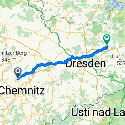
 Hauptstraße 22, Claußnitz nach Reichenberger Straße 9, Dresden
- Distance
- 75.9 km
- Ascent
- 773 m
- Descent
- 925 m
- Location
- Claußnitz, Saxony, Germany
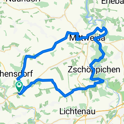 Markersdorf-Krumbach-Mittweida-Markersdorf
- Distance
- 38.3 km
- Ascent
- 398 m
- Descent
- 372 m
- Location
- Claußnitz, Saxony, Germany
 4. Tag Claußnitz nach Pulsnitz
- Distance
- 106.1 km
- Ascent
- 958 m
- Descent
- 973 m
- Location
- Claußnitz, Saxony, Germany
 Sa6_1Diethensd-Chemnitztal-Markersd Bhf
- Distance
- 6.5 km
- Ascent
- 65 m
- Descent
- 88 m
- Location
- Claußnitz, Saxony, Germany
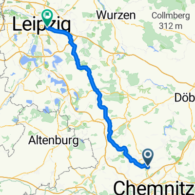 Chemnitztalstraße 48, Lichtenau nach Täubchenweg 69-73, Leipzig
- Distance
- 77 km
- Ascent
- 542 m
- Descent
- 692 m
- Location
- Claußnitz, Saxony, Germany
Open it in the app