

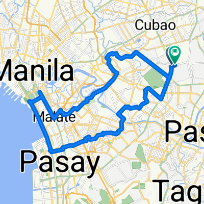
marcos sumulong taytay pasig
A cycling route starting in Pasig, National Capital Region, Philippines.
Overview
About this route
- 5 h 10 min
- Duration
- 38.6 km
- Distance
- 307 m
- Ascent
- 319 m
- Descent
- 7.5 km/h
- Avg. speed
- ---
- Max. altitude

Route photos

Route quality
Waytypes & surfaces along the route
Waytypes
Busy road
21.7 km
(56 %)
Road
12.6 km
(33 %)
Surfaces
Paved
26.7 km
(69 %)
Unpaved
0.1 km
(<1 %)
Asphalt
20.4 km
(53 %)
Concrete
6.3 km
(16 %)
Continue with Bikemap
Use, edit, or download this cycling route
You would like to ride marcos sumulong taytay pasig or customize it for your own trip? Here is what you can do with this Bikemap route:
Free features
- Save this route as favorite or in collections
- Copy & plan your own version of this route
- Sync your route with Garmin or Wahoo
Premium features
Free trial for 3 days, or one-time payment. More about Bikemap Premium.
- Navigate this route on iOS & Android
- Export a GPX / KML file of this route
- Create your custom printout (try it for free)
- Download this route for offline navigation
Discover more Premium features.
Get Bikemap PremiumFrom our community
Other popular routes starting in Pasig
 Wawa Dam 🌊
- Distance
- 71.7 km
- Ascent
- 988 m
- Descent
- 1,004 m
- Location
- Pasig, National Capital Region, Philippines
 Ortigas-Temple-Katipunan-Manggahan Loop
- Distance
- 16.7 km
- Ascent
- 198 m
- Descent
- 204 m
- Location
- Pasig, National Capital Region, Philippines
 People Power to Luneta and Back
- Distance
- 33.4 km
- Ascent
- 136 m
- Descent
- 135 m
- Location
- Pasig, National Capital Region, Philippines
 Maybunga Cong Bikers
- Distance
- 11.2 km
- Ascent
- 50 m
- Descent
- 43 m
- Location
- Pasig, National Capital Region, Philippines
 Mahabang Parang via Tikling
- Distance
- 19.1 km
- Ascent
- 261 m
- Descent
- 99 m
- Location
- Pasig, National Capital Region, Philippines
 Work to House 8.22.2018
- Distance
- 13.6 km
- Ascent
- 163 m
- Descent
- 213 m
- Location
- Pasig, National Capital Region, Philippines
 Camino Verde Road 1605, Pasig to Sitio de Asis Street 123, Manila
- Distance
- 15 km
- Ascent
- 132 m
- Descent
- 132 m
- Location
- Pasig, National Capital Region, Philippines
 Saturday Morning Ride
- Distance
- 10.2 km
- Ascent
- 42 m
- Descent
- 48 m
- Location
- Pasig, National Capital Region, Philippines
Open it in the app