

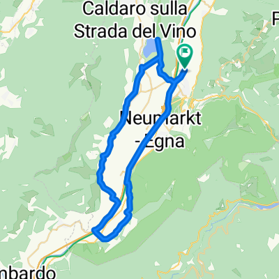
Tour Caldaro
A cycling route starting in Auer, Trentino-Alto Adige, Italy.
Overview
About this route
Circular itinerary connecting Ora, Bolzano, Appiano, and Caldaro. Almost entirely on cycle paths. Optional variant for Lake Monticolo.
- -:--
- Duration
- 54.6 km
- Distance
- 404 m
- Ascent
- 424 m
- Descent
- ---
- Avg. speed
- ---
- Max. altitude

Route quality
Waytypes & surfaces along the route
Waytypes
Cycleway
18.6 km
(34 %)
Quiet road
13.7 km
(25 %)
Surfaces
Paved
42 km
(77 %)
Unpaved
7.6 km
(14 %)
Asphalt
39.3 km
(72 %)
Gravel
6.6 km
(12 %)
Continue with Bikemap
Use, edit, or download this cycling route
You would like to ride Tour Caldaro or customize it for your own trip? Here is what you can do with this Bikemap route:
Free features
- Save this route as favorite or in collections
- Copy & plan your own version of this route
- Sync your route with Garmin or Wahoo
Premium features
Free trial for 3 days, or one-time payment. More about Bikemap Premium.
- Navigate this route on iOS & Android
- Export a GPX / KML file of this route
- Create your custom printout (try it for free)
- Download this route for offline navigation
Discover more Premium features.
Get Bikemap PremiumFrom our community
Other popular routes starting in Auer
 Tour 07, Südtiroler Weinstrasse
- Distance
- 43.5 km
- Ascent
- 226 m
- Descent
- 225 m
- Location
- Auer, Trentino-Alto Adige, Italy
 Etschtal - Flach, aber schön
- Distance
- 61.8 km
- Ascent
- 398 m
- Descent
- 398 m
- Location
- Auer, Trentino-Alto Adige, Italy
 Tag 3: Bozen, Kalterersee, Auer
- Distance
- 45.7 km
- Ascent
- 234 m
- Descent
- 265 m
- Location
- Auer, Trentino-Alto Adige, Italy
 FRCastel Auer - Bozen_Etsch
- Distance
- 23.2 km
- Ascent
- 160 m
- Descent
- 146 m
- Location
- Auer, Trentino-Alto Adige, Italy
 Tour Caldaro
- Distance
- 54.6 km
- Ascent
- 404 m
- Descent
- 424 m
- Location
- Auer, Trentino-Alto Adige, Italy
 FR CastelAuer - Bozen_Montiggler Seen
- Distance
- 30.6 km
- Ascent
- 555 m
- Descent
- 541 m
- Location
- Auer, Trentino-Alto Adige, Italy
 Pfatten nach Viale Roma, Levico Terme (Löweneck)
- Distance
- 63.6 km
- Ascent
- 602 m
- Descent
- 304 m
- Location
- Auer, Trentino-Alto Adige, Italy
 I - Südtirol - Traminer Runde - 37 km
- Distance
- 36.7 km
- Ascent
- 274 m
- Descent
- 274 m
- Location
- Auer, Trentino-Alto Adige, Italy
Open it in the app