

Italia Mayo 2018
Dia 5 Monte San Angelo a Severo
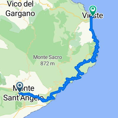
A cycling route starting in Monte Sant'Angelo, Apulia, Italy.
Overview
About this route
Km 22 San Giovanni Di Rotondo
- -:--
- Duration
- 57.3 km
- Distance
- 433 m
- Ascent
- 1,131 m
- Descent
- ---
- Avg. speed
- ---
- Max. altitude

Part of
Italia Mayo 2018
11 stages
Route quality
Waytypes & surfaces along the route
Waytypes
Quiet road
15.5 km
(27 %)
Track
14.3 km
(25 %)
Surfaces
Paved
24.1 km
(42 %)
Unpaved
6.3 km
(11 %)
Asphalt
24.1 km
(42 %)
Gravel
5.7 km
(10 %)
Continue with Bikemap
Use, edit, or download this cycling route
You would like to ride Dia 5 Monte San Angelo a Severo or customize it for your own trip? Here is what you can do with this Bikemap route:
Free features
- Save this route as favorite or in collections
- Copy & plan your own version of this route
- Sync your route with Garmin or Wahoo
Premium features
Free trial for 3 days, or one-time payment. More about Bikemap Premium.
- Navigate this route on iOS & Android
- Export a GPX / KML file of this route
- Create your custom printout (try it for free)
- Download this route for offline navigation
Discover more Premium features.
Get Bikemap PremiumFrom our community
Other popular routes starting in Monte Sant'Angelo
 27.5. Monte Sant' Angelo - Vieste
- Distance
- 69.3 km
- Ascent
- 794 m
- Descent
- 1,562 m
- Location
- Monte Sant'Angelo, Apulia, Italy
 Abbazia Pulsano
- Distance
- 2.7 km
- Ascent
- 139 m
- Descent
- 197 m
- Location
- Monte Sant'Angelo, Apulia, Italy
 bdm-monte sant'angelo
- Distance
- 17.4 km
- Ascent
- 816 m
- Descent
- 673 m
- Location
- Monte Sant'Angelo, Apulia, Italy
 Monte san Angelo- San Giovanni Rotondo-San Marco in Lamis-San Nicandro Garganic-
- Distance
- 131.4 km
- Ascent
- 1,517 m
- Descent
- 1,655 m
- Location
- Monte Sant'Angelo, Apulia, Italy
 Dia 5 Monte San Angelo a Severo
- Distance
- 57.3 km
- Ascent
- 433 m
- Descent
- 1,131 m
- Location
- Monte Sant'Angelo, Apulia, Italy
 scannamugliera
- Distance
- 11.6 km
- Ascent
- 32 m
- Descent
- 812 m
- Location
- Monte Sant'Angelo, Apulia, Italy
 monte Sant’Angelo- mattinata b&b
- Distance
- 18 km
- Ascent
- 251 m
- Descent
- 1,050 m
- Location
- Monte Sant'Angelo, Apulia, Italy
 6b Monte Sant' Angelo - Barletta
- Distance
- 104.3 km
- Ascent
- 459 m
- Descent
- 1,224 m
- Location
- Monte Sant'Angelo, Apulia, Italy
Open it in the app