
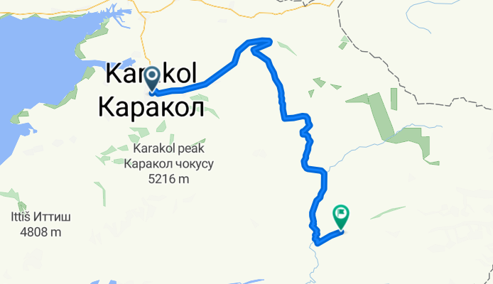
Karakol-Enilchek-Helipad Khan Tengri
A cycling route starting in Karakol, Issyk-Kul’skaya Oblast’, Kyrgyzstan.
Overview
About this route
Two day mountain bike ride, very nice.
- -:--
- Duration
- 156.4 km
- Distance
- 3,296 m
- Ascent
- 2,482 m
- Descent
- ---
- Avg. speed
- ---
- Max. altitude
Route highlights
Points of interest along the route

Point of interest after 101.9 km

Point of interest after 106.4 km

Point of interest after 107.5 km

Point of interest after 110.1 km
Continue with Bikemap
Use, edit, or download this cycling route
You would like to ride Karakol-Enilchek-Helipad Khan Tengri or customize it for your own trip? Here is what you can do with this Bikemap route:
Free features
- Save this route as favorite or in collections
- Copy & plan your own version of this route
- Split it into stages to create a multi-day tour
- Sync your route with Garmin or Wahoo
Premium features
Free trial for 3 days, or one-time payment. More about Bikemap Premium.
- Navigate this route on iOS & Android
- Export a GPX / KML file of this route
- Create your custom printout (try it for free)
- Download this route for offline navigation
Discover more Premium features.
Get Bikemap PremiumFrom our community
Other popular routes starting in Karakol
 Karakol-Km 108
- Distance
- 108.1 km
- Ascent
- 274 m
- Descent
- 425 m
- Location
- Karakol, Issyk-Kul’skaya Oblast’, Kyrgyzstan
 Tian-shan lakes
- Distance
- 751.5 km
- Ascent
- 6,173 m
- Descent
- 5,887 m
- Location
- Karakol, Issyk-Kul’skaya Oblast’, Kyrgyzstan
 Day 13
- Distance
- 109.7 km
- Ascent
- 459 m
- Descent
- 478 m
- Location
- Karakol, Issyk-Kul’skaya Oblast’, Kyrgyzstan
 Door de valleien bij Karakol 2
- Distance
- 95.4 km
- Ascent
- 2,742 m
- Descent
- 2,285 m
- Location
- Karakol, Issyk-Kul’skaya Oblast’, Kyrgyzstan
 KAZ_KIR_12.jun_4.dien
- Distance
- 151.9 km
- Ascent
- 646 m
- Descent
- 810 m
- Location
- Karakol, Issyk-Kul’skaya Oblast’, Kyrgyzstan
 kir 2
kir 2- Distance
- 935.2 km
- Ascent
- 4,358 m
- Descent
- 5,339 m
- Location
- Karakol, Issyk-Kul’skaya Oblast’, Kyrgyzstan
 От Unnamed Road, Каракол до Ala-Kul Lake Camp
- Distance
- 27.2 km
- Ascent
- 2,078 m
- Descent
- 385 m
- Location
- Karakol, Issyk-Kul’skaya Oblast’, Kyrgyzstan
 От Toktogula 211, Каракол до Unnamed Road
- Distance
- 13.1 km
- Ascent
- 46 m
- Descent
- 167 m
- Location
- Karakol, Issyk-Kul’skaya Oblast’, Kyrgyzstan
Open it in the app