

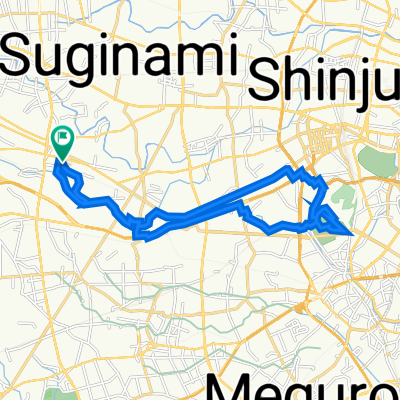
cycling around tama cemetery
A cycling route starting in Mitaka-shi, Tokyo, Japan.
Overview
About this route
- 38 min
- Duration
- 12.9 km
- Distance
- 416 m
- Ascent
- 421 m
- Descent
- 20.2 km/h
- Avg. speed
- ---
- Max. altitude
Continue with Bikemap
Use, edit, or download this cycling route
You would like to ride cycling around tama cemetery or customize it for your own trip? Here is what you can do with this Bikemap route:
Free features
- Save this route as favorite or in collections
- Copy & plan your own version of this route
- Sync your route with Garmin or Wahoo
Premium features
Free trial for 3 days, or one-time payment. More about Bikemap Premium.
- Navigate this route on iOS & Android
- Export a GPX / KML file of this route
- Create your custom printout (try it for free)
- Download this route for offline navigation
Discover more Premium features.
Get Bikemap PremiumFrom our community
Other popular routes starting in Mitaka-shi
 高井戸東3丁目20-28, 杉並区 to 高井戸東3丁目20-28, 杉並区
- Distance
- 11 km
- Ascent
- 63 m
- Descent
- 62 m
- Location
- Mitaka-shi, Tokyo, Japan
 高井戸東3丁目20-28, 杉並区 to 高井戸東3丁目20-28, 杉並区
- Distance
- 28.9 km
- Ascent
- 80 m
- Descent
- 79 m
- Location
- Mitaka-shi, Tokyo, Japan
 高井戸西1丁目12-16, 杉並区 to 高井戸東3丁目20-28, 杉並区
- Distance
- 1.7 km
- Ascent
- 16 m
- Descent
- 21 m
- Location
- Mitaka-shi, Tokyo, Japan
 高井戸東3丁目20-28, 杉並区 to 高井戸西1丁目12-16, 杉並区
- Distance
- 1.8 km
- Ascent
- 10 m
- Descent
- 10 m
- Location
- Mitaka-shi, Tokyo, Japan
 高井戸東3丁目20-28, 杉並区 to 高井戸東3丁目20-28, 杉並区
- Distance
- 21.8 km
- Ascent
- 99 m
- Descent
- 102 m
- Location
- Mitaka-shi, Tokyo, Japan
 June 2, 2020
- Distance
- 59.1 km
- Ascent
- 612 m
- Descent
- 611 m
- Location
- Mitaka-shi, Tokyo, Japan
 Setagaya part 3
- Distance
- 9.3 km
- Ascent
- 33 m
- Descent
- 39 m
- Location
- Mitaka-shi, Tokyo, Japan
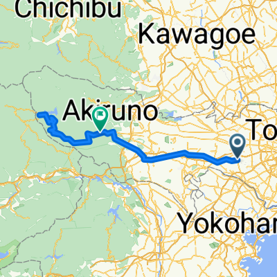 Setagaya_Akiruno
- Distance
- 127.7 km
- Ascent
- 1,681 m
- Descent
- 1,485 m
- Location
- Mitaka-shi, Tokyo, Japan
Open it in the app