

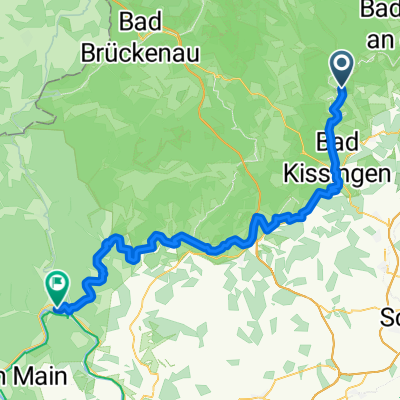
1. Tag Bad Bocklet - Hildburghausen
A cycling route starting in Bad Bocklet, Bavaria, Germany.
Overview
About this route
- -:--
- Duration
- 75.2 km
- Distance
- 391 m
- Ascent
- 230 m
- Descent
- ---
- Avg. speed
- ---
- Max. altitude

Route quality
Waytypes & surfaces along the route
Waytypes
Road
16.5 km
(22 %)
Quiet road
13.5 km
(18 %)
Surfaces
Paved
56.4 km
(75 %)
Unpaved
3 km
(4 %)
Asphalt
56.4 km
(75 %)
Gravel
3 km
(4 %)
Undefined
15.8 km
(21 %)
Route highlights
Points of interest along the route
Point of interest after 33.3 km
1. Pause Parkplatz Wülfershausen Papamobil
Continue with Bikemap
Use, edit, or download this cycling route
You would like to ride 1. Tag Bad Bocklet - Hildburghausen or customize it for your own trip? Here is what you can do with this Bikemap route:
Free features
- Save this route as favorite or in collections
- Copy & plan your own version of this route
- Sync your route with Garmin or Wahoo
Premium features
Free trial for 3 days, or one-time payment. More about Bikemap Premium.
- Navigate this route on iOS & Android
- Export a GPX / KML file of this route
- Create your custom printout (try it for free)
- Download this route for offline navigation
Discover more Premium features.
Get Bikemap PremiumFrom our community
Other popular routes starting in Bad Bocklet
 Aschach - Kreuzberg - Aschach
- Distance
- 55.3 km
- Ascent
- 959 m
- Descent
- 956 m
- Location
- Bad Bocklet, Bavaria, Germany
 Rund um den Kreutzberg
- Distance
- 68.6 km
- Ascent
- 1,156 m
- Descent
- 1,147 m
- Location
- Bad Bocklet, Bavaria, Germany
 Dionysiusstraße 6, Bad Kissingen nach Dionysiusstraße 1, Bad Kissingen
- Distance
- 14.8 km
- Ascent
- 263 m
- Descent
- 263 m
- Location
- Bad Bocklet, Bavaria, Germany
 Bad Bocklet bis Lohr am Main
- Distance
- 87.2 km
- Ascent
- 262 m
- Descent
- 309 m
- Location
- Bad Bocklet, Bavaria, Germany
 Bad Bocklet - Waldsassen
- Distance
- 468.3 km
- Ascent
- 1,568 m
- Descent
- 1,573 m
- Location
- Bad Bocklet, Bavaria, Germany
 Tag 1 2019 - Bad Bocklet/Gemünden
- Distance
- 64.2 km
- Ascent
- 214 m
- Descent
- 278 m
- Location
- Bad Bocklet, Bavaria, Germany
 Drei-Täler-Tour durch die Südrhön
- Distance
- 25.8 km
- Ascent
- 213 m
- Descent
- 213 m
- Location
- Bad Bocklet, Bavaria, Germany
 1. Tag Bad Bocklet - Hildburghausen
- Distance
- 75.2 km
- Ascent
- 391 m
- Descent
- 230 m
- Location
- Bad Bocklet, Bavaria, Germany
Open it in the app