

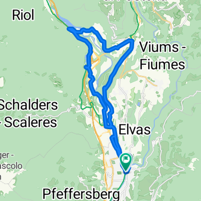
natz albeins
A cycling route starting in Brixen, Trentino-Alto Adige, Italy.
Overview
About this route
Data Value Unit Duration 1:28:00 Minimum Heart Rate 81 bpm Average Heart Rate 150 bpm Maximum Heart Rate 171 bpm Standard Deviation 14.9 bpm
Minimum Speed 7.9 km/h Average Speed 24.5 km/h Maximum Speed 57.5 km/h Distance 35.9 km
Minimum Cadence 38 rpm Average Cadence 77 rpm Maximum Cadence 112 rpm
Minimum Elevation 479 m Average Elevation 619 m Maximum Elevation 836 m Elevation Gain 505 m Elevation Loss 503 m (Ascents/Descents): 2
- -:--
- Duration
- 35.6 km
- Distance
- 561 m
- Ascent
- 554 m
- Descent
- ---
- Avg. speed
- 897 m
- Max. altitude
Route quality
Waytypes & surfaces along the route
Waytypes
Road
13.5 km
(38 %)
Quiet road
7.1 km
(20 %)
Surfaces
Paved
29.9 km
(84 %)
Asphalt
29.9 km
(84 %)
Undefined
5.7 km
(16 %)
Continue with Bikemap
Use, edit, or download this cycling route
You would like to ride natz albeins or customize it for your own trip? Here is what you can do with this Bikemap route:
Free features
- Save this route as favorite or in collections
- Copy & plan your own version of this route
- Sync your route with Garmin or Wahoo
Premium features
Free trial for 3 days, or one-time payment. More about Bikemap Premium.
- Navigate this route on iOS & Android
- Export a GPX / KML file of this route
- Create your custom printout (try it for free)
- Download this route for offline navigation
Discover more Premium features.
Get Bikemap PremiumFrom our community
Other popular routes starting in Brixen
 Route von Köstlanerstraße
- Distance
- 21.9 km
- Ascent
- 301 m
- Descent
- 352 m
- Location
- Brixen, Trentino-Alto Adige, Italy
 natz albeins
- Distance
- 35.6 km
- Ascent
- 561 m
- Descent
- 554 m
- Location
- Brixen, Trentino-Alto Adige, Italy
 brixen-trento
- Distance
- 96.8 km
- Ascent
- 93 m
- Descent
- 474 m
- Location
- Brixen, Trentino-Alto Adige, Italy
 Alpe di Siusi climb
- Distance
- 48.2 km
- Ascent
- 2,108 m
- Descent
- 696 m
- Location
- Brixen, Trentino-Alto Adige, Italy
 Route im Schneckentempo in Waidbruck
- Distance
- 20.6 km
- Ascent
- 131 m
- Descent
- 225 m
- Location
- Brixen, Trentino-Alto Adige, Italy
 🚴♀️E*Bike🇮🇩 16.04.27. 2 Tag BRIXEN - BOZEN
- Distance
- 40.6 km
- Ascent
- 85 m
- Descent
- 377 m
- Location
- Brixen, Trentino-Alto Adige, Italy
 Cleran to Sankt Martin in Thurn +a bit more
- Distance
- 49.6 km
- Ascent
- 2,196 m
- Descent
- 1,145 m
- Location
- Brixen, Trentino-Alto Adige, Italy
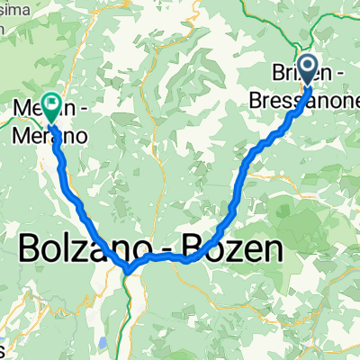 Brixen - Meran
- Distance
- 73.5 km
- Ascent
- 754 m
- Descent
- 1,000 m
- Location
- Brixen, Trentino-Alto Adige, Italy
Open it in the app