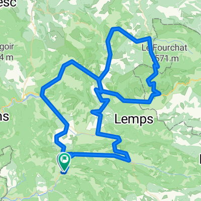
Test
A cycling route starting in Buis-les-Baronnies, Auvergne-Rh么ne-Alpes, France.
Overview
About this route
- -:--
- Duration
- 43.8 km
- Distance
- 668 m
- Ascent
- 669 m
- Descent
- ---
- Avg. speed
- ---
- Avg. speed
Route quality
Waytypes & surfaces along the route
Waytypes
Busy road
29.6 km
(68 %)
Road
9.3 km
(21 %)
Surfaces
Paved
16.1 km
(37 %)
Asphalt
15.5 km
(35 %)
Paved (undefined)
0.6 km
(1 %)
Undefined
27.8 km
(63 %)
Continue with Bikemap
Use, edit, or download this cycling route
You would like to ride Test or customize it for your own trip? Here is what you can do with this Bikemap route:
Free features
- Save this route as favorite or in collections
- Copy & plan your own version of this route
- Sync your route with Garmin or Wahoo
Premium features
Free trial for 3 days, or one-time payment. More about Bikemap Premium.
- Navigate this route on iOS & Android
- Export a GPX / KML file of this route
- Create your custom printout (try it for free)
- Download this route for offline navigation
Discover more Premium features.
Get Bikemap PremiumFrom our community
Other popular routes starting in Buis-les-Baronnies
- Mont-Ventoux par Sault
- Distance
- 100.2 km
- Ascent
- 1,940 m
- Descent
- 1,936 m
- Location
- Buis-les-Baronnies, Auvergne-Rh么ne-Alpes, France
- boucle Buis, col de Fontaube, Savoillan
- Distance
- 54.8 km
- Ascent
- 760 m
- Descent
- 760 m
- Location
- Buis-les-Baronnies, Auvergne-Rh么ne-Alpes, France
- von sainte jalle 眉ber den mont vedoux
- Distance
- 143 km
- Ascent
- 3,795 m
- Descent
- 3,664 m
- Location
- Buis-les-Baronnies, Auvergne-Rh么ne-Alpes, France
- F/Propiac-Mirabel-Gouvernet-ret
- Distance
- 75.8 km
- Ascent
- 753 m
- Descent
- 781 m
- Location
- Buis-les-Baronnies, Auvergne-Rh么ne-Alpes, France
- BlB, CdE, CdS, Nyons, BlB
- Distance
- 92.5 km
- Ascent
- 1,175 m
- Descent
- 1,175 m
- Location
- Buis-les-Baronnies, Auvergne-Rh么ne-Alpes, France
- Drome Proven莽ale V2
- Distance
- 105.2 km
- Ascent
- 1,671 m
- Descent
- 1,670 m
- Location
- Buis-les-Baronnies, Auvergne-Rh么ne-Alpes, France
- Test
- Distance
- 43.8 km
- Ascent
- 668 m
- Descent
- 669 m
- Location
- Buis-les-Baronnies, Auvergne-Rh么ne-Alpes, France
- Circuit 3 Buis - Gorges de la Nesque - Buis par Malauc猫ne
- Distance
- 122 km
- Ascent
- 1,099 m
- Descent
- 1,097 m
- Location
- Buis-les-Baronnies, Auvergne-Rh么ne-Alpes, France
Open it in the app