

Plamort Trail
A cycling route starting in Nauders, Tyrol, Austria.
Overview
About this route
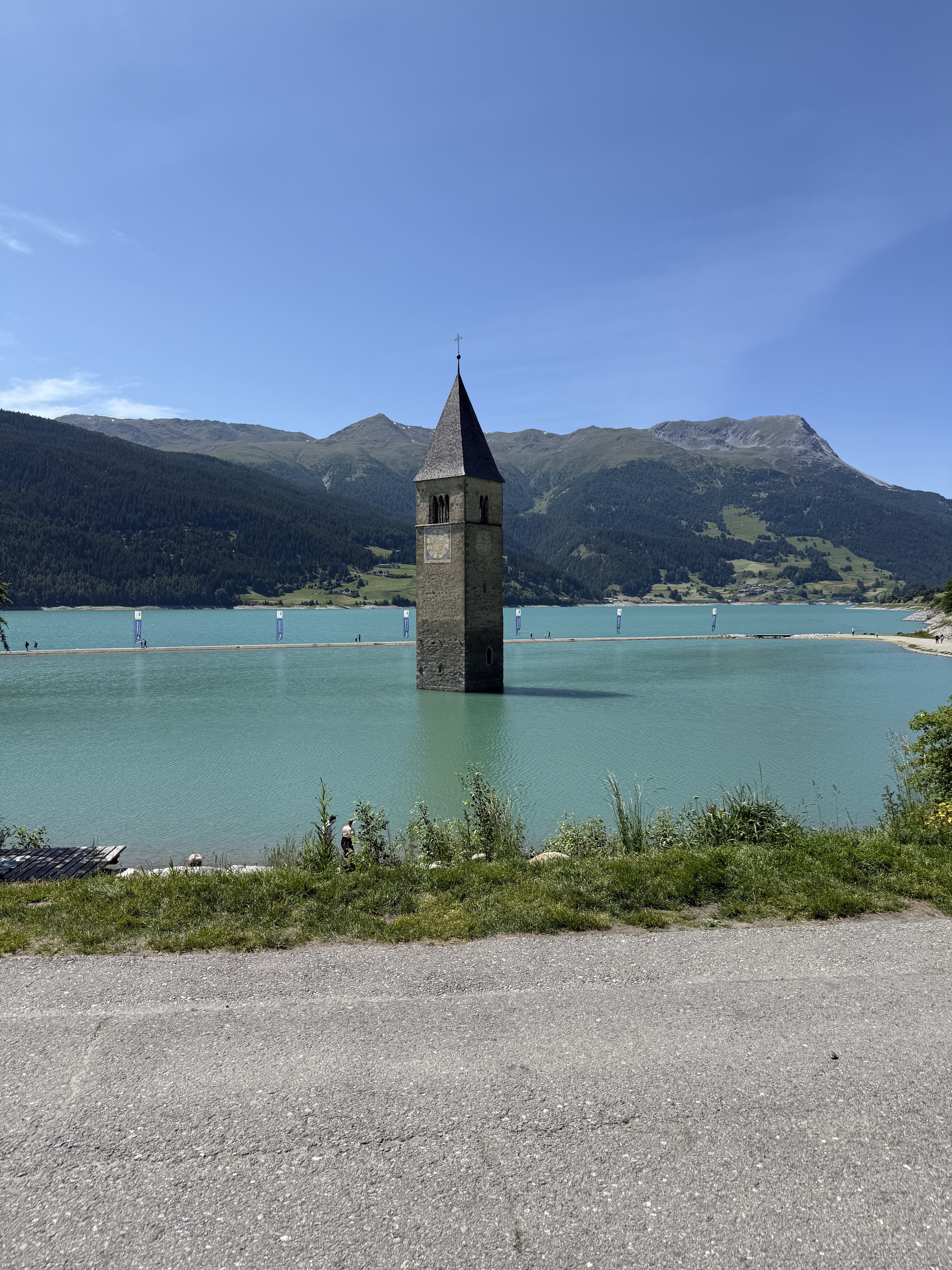
Grenzenloses Abfahrtsvergnügen und immer wieder herrliche Ausblicke auf den stahlblauen Reschensee – der Plamort Trail vom Hochplateau hinab nach Reschen ist Teil der 3-Länder-Enduro-Trails und ein echter Klassiker. Er ist ein absolutes Muss bei jedem Mountainbike-Besuch in Nauders. Mit einer Gesamtlänge von 5,5 Kilometern bietet dieser Trail ein scheinbar endloses Abfahrtsvergnügen.
- -:--
- Duration
- 5.5 km
- Distance
- 58 m
- Ascent
- 672 m
- Descent
- ---
- Avg. speed
- ---
- Max. altitude

Route photos


Continue with Bikemap
Use, edit, or download this cycling route
You would like to ride Plamort Trail or customize it for your own trip? Here is what you can do with this Bikemap route:
Free features
- Save this route as favorite or in collections
- Copy & plan your own version of this route
- Sync your route with Garmin or Wahoo
Premium features
Free trial for 3 days, or one-time payment. More about Bikemap Premium.
- Navigate this route on iOS & Android
- Export a GPX / KML file of this route
- Create your custom printout (try it for free)
- Download this route for offline navigation
Discover more Premium features.
Get Bikemap PremiumFrom our community
Other popular routes starting in Nauders
 Fuhrmannsloch, Nauders nach Reschenstraße, Nauders
- Distance
- 43.6 km
- Ascent
- 613 m
- Descent
- 643 m
- Location
- Nauders, Tyrol, Austria
 3 Ländertour die Uina-Schlucht hoch
- Distance
- 73.6 km
- Ascent
- 1,822 m
- Descent
- 1,822 m
- Location
- Nauders, Tyrol, Austria
 Von Nauders bis Menaggio
- Distance
- 80.8 km
- Ascent
- 3,585 m
- Descent
- 3,727 m
- Location
- Nauders, Tyrol, Austria
 Favorit-1. Etape_Nauders-Meran_87km
- Distance
- 86.6 km
- Ascent
- 856 m
- Descent
- 1,963 m
- Location
- Nauders, Tyrol, Austria
 Pfunds - Graun
- Distance
- 54 km
- Ascent
- 788 m
- Descent
- 1,424 m
- Location
- Nauders, Tyrol, Austria
 Plamort Trail
- Distance
- 5.5 km
- Ascent
- 58 m
- Descent
- 672 m
- Location
- Nauders, Tyrol, Austria
 ALPSKÉ PRŮSMYKY A JEZERA NA KOLE www.nomad.cz
- Distance
- 421.6 km
- Ascent
- 8,346 m
- Descent
- 8,250 m
- Location
- Nauders, Tyrol, Austria
 Rundwanderung Grosserßer Mutzkopf to Via Roma
- Distance
- 293 km
- Ascent
- 3,259 m
- Descent
- 4,972 m
- Location
- Nauders, Tyrol, Austria
Open it in the app