- 16.2 km
- 76 m
- 57 m
- Grigny-sur-Rh么ne, Auvergne-Rh么ne-Alpes, France
Givors - saint-Etienne - reconnaissance 6 avril 2018
A cycling route starting in Grigny-sur-Rh么ne, Auvergne-Rh么ne-Alpes, France.
Overview
About this route
- -:--
- Duration
- 46.8 km
- Distance
- 469 m
- Ascent
- 110 m
- Descent
- ---
- Avg. speed
- ---
- Max. altitude
created this 7 years ago
Route quality
Waytypes & surfaces along the route
Waytypes
Quiet road
18.7 km
(40 %)
Road
7 km
(15 %)
Surfaces
Paved
27.1 km
(58 %)
Unpaved
1.4 km
(3 %)
Asphalt
26.7 km
(57 %)
Gravel
0.9 km
(2 %)
Route highlights
Points of interest along the route
Point of interest after 4.3 km
Le p么le m茅tropolitain
Point of interest after 4.7 km
point compliqu茅 n掳 1 - Givors
Point of interest after 11.4 km
point complique n掳2 Saint-Romain - D488
Point of interest after 14.9 km
Le Rocher perc茅
Point of interest after 15 km
Point compliqu茅 N掳3 : roche perc茅e
Point of interest after 17.2 km
point compliqu茅 N掳4 : D488 vers Ch芒teauneuf
Point of interest after 20.2 km
Point compliqu茅 n掳5 : entr茅e rive de Gier D30 - D88 - Avenue Juin
Point of interest after 22.1 km
Pause gare de rive de Gier
Point of interest after 23.1 km
point compliqu茅 N掳6 : D65-A47-RD88
Point of interest after 26.1 km
point compliqu茅 N掳7 : D106 - rue de la Rive (la Grand Croix)
Point of interest after 29.5 km
Parc municipal l'Horme
Point of interest after 30.5 km
Point compliqu茅 n掳9 : D37 - Route de LYon - L'Horme
Point of interest after 32 km
Point compliqu茅 N掳10 : Benoit Oriol - Victor Hugo -Saint-Chamond
Point of interest after 32.3 km
Parc Nelson Mand茅la - Saint-Chamond
Point of interest after 32.4 km
Point compliqu茅 N掳11 : Lamartine - Saint-Chamond
Point of interest after 33 km
Point compliqu茅 N掳12 : rue saint-etienne - rue sibert : Saint-Chamond
Point of interest after 41.4 km
Point compliqu茅 N掳13 Terrenoire
Point of interest after 44.9 km
Point compliqu茅 N掳13 : Alli茅s - Niemen -Infanterie
Point of interest after 45.1 km
point compliqu茅 N掳14 : Verpilleux / Montat
Point of interest after 45.5 km
Point compliqu茅 N掳15 : Gris de lin / montat (bd urbain)
Point of interest after 45.7 km
Saint-Etienne M茅tropole
Continue with Bikemap
Use, edit, or download this cycling route
You would like to ride Givors - saint-Etienne - reconnaissance 6 avril 2018 or customize it for your own trip? Here is what you can do with this Bikemap route:
Free features
- Save this route as favorite or in collections
- Copy & plan your own version of this route
- Sync your route with Garmin or Wahoo
Premium features
Free trial for 3 days, or one-time payment. More about Bikemap Premium.
- Navigate this route on iOS & Android
- Export a GPX / KML file of this route
- Create your custom printout (try it for free)
- Download this route for offline navigation
Discover more Premium features.
Get Bikemap PremiumFrom our community
Other popular routes starting in Grigny-sur-Rh么ne
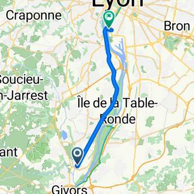
- Visite rapide en Grigny
- 32 Chemin des Charmes, Millery 脿 88 bis Rue Andr茅 Sabatier, Grigny
- 18 km
- 190 m
- 194 m
- Grigny-sur-Rh么ne, Auvergne-Rh么ne-Alpes, France
- chassag
- 26.8 km
- 281 m
- 283 m
- Grigny-sur-Rh么ne, Auvergne-Rh么ne-Alpes, France
- saint andeol
- 21.7 km
- 314 m
- 272 m
- Grigny-sur-Rh么ne, Auvergne-Rh么ne-Alpes, France
- Givors - saint-Etienne - reconnaissance 6 avril 2018
- 46.8 km
- 469 m
- 110 m
- Grigny-sur-Rh么ne, Auvergne-Rh么ne-Alpes, France
- FILLONIERE
- 34.7 km
- 544 m
- 544 m
- Grigny-sur-Rh么ne, Auvergne-Rh么ne-Alpes, France
- MONTAGNY
- 24.1 km
- 447 m
- 449 m
- Grigny-sur-Rh么ne, Auvergne-Rh么ne-Alpes, France
- De 34 Avenue des Arondi猫res, Grigny 脿 1 Rue Antonin Perrin, Lyon
- 16.8 km
- 41 m
- 55 m
- Grigny-sur-Rh么ne, Auvergne-Rh么ne-Alpes, France
Open it in the app


