

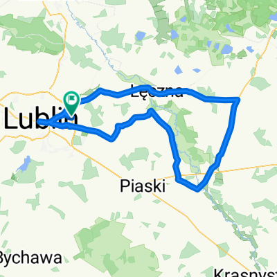
Lublin-WolaUhruska
A cycling route starting in Jakubowice Murowane, Lublin Voivodeship, Poland.
Overview
About this route
- -:--
- Duration
- 108.3 km
- Distance
- 165 m
- Ascent
- 128 m
- Descent
- ---
- Avg. speed
- ---
- Max. altitude
Route quality
Waytypes & surfaces along the route
Waytypes
Road
61.7 km
(57 %)
Quiet road
28.2 km
(26 %)
Surfaces
Paved
61.7 km
(57 %)
Unpaved
7.6 km
(7 %)
Asphalt
61.7 km
(57 %)
Gravel
2.2 km
(2 %)
Route highlights
Points of interest along the route
Accommodation after 48.2 km
Ośrodek Wypoczynkowy ŁUKCZE Pole namiotowe nad jeziorem Krasne Krasne 42, 21-109 UŚCIMÓW http://www.lukcze.pl/index.html Rezerwacja domków oraz informacja czynna w godz. od 8.00 do 16.00 tel. +48 728 832 846 e-mail: info@lukcze.pl Pole namiotowe: 35zl 2os/doba namiot 15zl nam/doba pobyt 8zł os/doba pra 10zł doba klimatyczna 2zl os/doba
Accommodation after 48.2 km
Pole namiotowe, kamping Resort Piaseczno Rozpłucie Pierwsze 1D , 21-075 Rozpłucie Pierwsze https://www.pola-namiotowe.info/pl/resort-piaseczno,638,podglad.html tel. 503 015 091
Accommodation after 50.4 km
Pole namiotowe, kamping Ośrodek Wypoczynkowy ZAGŁĘBOCZE Lejno 21-230 Sosnowica Rezerwacja od 8.00 do 16.00 tel. +48 885 119 981 Namiot 15zl nam/doba Pobyt 8zl os/doba Prąd 10zl /doba
Continue with Bikemap
Use, edit, or download this cycling route
You would like to ride Lublin-WolaUhruska or customize it for your own trip? Here is what you can do with this Bikemap route:
Free features
- Save this route as favorite or in collections
- Copy & plan your own version of this route
- Split it into stages to create a multi-day tour
- Sync your route with Garmin or Wahoo
Premium features
Free trial for 3 days, or one-time payment. More about Bikemap Premium.
- Navigate this route on iOS & Android
- Export a GPX / KML file of this route
- Create your custom printout (try it for free)
- Download this route for offline navigation
Discover more Premium features.
Get Bikemap PremiumFrom our community
Other popular routes starting in Jakubowice Murowane
 Dys-Firlej przez Lubartów
- Distance
- 75.5 km
- Ascent
- 151 m
- Descent
- 149 m
- Location
- Jakubowice Murowane, Lublin Voivodeship, Poland
 2010.06.04
- Distance
- 107.5 km
- Ascent
- 102 m
- Descent
- 105 m
- Location
- Jakubowice Murowane, Lublin Voivodeship, Poland
 Szlak Gminy Niemce - zmodyfikowany
- Distance
- 50 km
- Ascent
- 149 m
- Descent
- 149 m
- Location
- Jakubowice Murowane, Lublin Voivodeship, Poland
 Lengthy bike tour from Lublin to Siedliszcze
- Distance
- 43.9 km
- Ascent
- 75 m
- Descent
- 96 m
- Location
- Jakubowice Murowane, Lublin Voivodeship, Poland
 Parczew 2017 dzień 2
- Distance
- 82.2 km
- Ascent
- 80 m
- Descent
- 109 m
- Location
- Jakubowice Murowane, Lublin Voivodeship, Poland
 wycieczka
- Distance
- 67.9 km
- Ascent
- 166 m
- Descent
- 166 m
- Location
- Jakubowice Murowane, Lublin Voivodeship, Poland
 Droga Krajowa do Turystyczna 33D
- Distance
- 12.8 km
- Ascent
- 314 m
- Descent
- 249 m
- Location
- Jakubowice Murowane, Lublin Voivodeship, Poland
 nad wode
- Distance
- 125.6 km
- Ascent
- 102 m
- Descent
- 137 m
- Location
- Jakubowice Murowane, Lublin Voivodeship, Poland
Open it in the app