

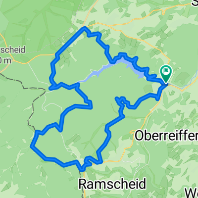
48A-Kall-Sötenich-Wildenberg
A cycling route starting in Hellenthal, North Rhine-Westphalia, Germany.
Overview
About this route
Heen via Reifferscheid
Terug via Benenberg
- -:--
- Duration
- 65.7 km
- Distance
- 751 m
- Ascent
- 745 m
- Descent
- ---
- Avg. speed
- ---
- Max. altitude
Route quality
Waytypes & surfaces along the route
Waytypes
Busy road
37.5 km
(57 %)
Road
14.8 km
(23 %)
Surfaces
Paved
43.4 km
(66 %)
Unpaved
1.4 km
(2 %)
Asphalt
42 km
(64 %)
Gravel
1.1 km
(2 %)
Continue with Bikemap
Use, edit, or download this cycling route
You would like to ride 48A-Kall-Sötenich-Wildenberg or customize it for your own trip? Here is what you can do with this Bikemap route:
Free features
- Save this route as favorite or in collections
- Copy & plan your own version of this route
- Sync your route with Garmin or Wahoo
Premium features
Free trial for 3 days, or one-time payment. More about Bikemap Premium.
- Navigate this route on iOS & Android
- Export a GPX / KML file of this route
- Create your custom printout (try it for free)
- Download this route for offline navigation
Discover more Premium features.
Get Bikemap PremiumFrom our community
Other popular routes starting in Hellenthal
 Hellenthal Ländchen Kall
- Distance
- 37 km
- Ascent
- 555 m
- Descent
- 555 m
- Location
- Hellenthal, North Rhine-Westphalia, Germany
 Platißbach
- Distance
- 20.3 km
- Ascent
- 377 m
- Descent
- 376 m
- Location
- Hellenthal, North Rhine-Westphalia, Germany
 Große Runde mit Gegenwind
- Distance
- 85.6 km
- Ascent
- 644 m
- Descent
- 644 m
- Location
- Hellenthal, North Rhine-Westphalia, Germany
 2025 Tag 8 Hellenthal-Waldfeucht
- Distance
- 101.6 km
- Ascent
- 625 m
- Descent
- 1,005 m
- Location
- Hellenthal, North Rhine-Westphalia, Germany
 Prethtal - Narzissenwiesen - Oleftalsperre
- Distance
- 31.9 km
- Ascent
- 376 m
- Descent
- 376 m
- Location
- Hellenthal, North Rhine-Westphalia, Germany
 tour6
tour6- Distance
- 33.2 km
- Ascent
- 657 m
- Descent
- 654 m
- Location
- Hellenthal, North Rhine-Westphalia, Germany
 Jan De Laet Fietsweekend Kris 201906 Maandag
- Distance
- 57 km
- Ascent
- 530 m
- Descent
- 861 m
- Location
- Hellenthal, North Rhine-Westphalia, Germany
 EifelSpur Westwall (Gemeinde Hellenthal)
- Distance
- 13.1 km
- Ascent
- 244 m
- Descent
- 241 m
- Location
- Hellenthal, North Rhine-Westphalia, Germany
Open it in the app