

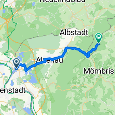
Spessart South-West Extreme Part I
A cycling route starting in Kahl am Main, Bavaria, Germany.
Overview
About this route
Tour nur für MTB geeignet. Ein gewisses Maß an Kondition und fahrerischem Können sollte vorhanden sein. Extrem sind die vielen kleinen, aber sehr steilen, Steigungen, wie auch zwei nette Downhillpassagen. Wer genügend Power besitzt, kann die Tour durchfahren. Highlights: Trail in die Rückersbacher Schlucht; schneller technischer Downhill vom Hahnenkamm. Kompression an alten Bunkeranlagen vom II. Weltkrieg. Ein- und Ausrollphase ist vorhanden.
- -:--
- Duration
- 48.3 km
- Distance
- 851 m
- Ascent
- 851 m
- Descent
- ---
- Avg. speed
- ---
- Max. altitude

Continue with Bikemap
Use, edit, or download this cycling route
You would like to ride Spessart South-West Extreme Part I or customize it for your own trip? Here is what you can do with this Bikemap route:
Free features
- Save this route as favorite or in collections
- Copy & plan your own version of this route
- Sync your route with Garmin or Wahoo
Premium features
Free trial for 3 days, or one-time payment. More about Bikemap Premium.
- Navigate this route on iOS & Android
- Export a GPX / KML file of this route
- Create your custom printout (try it for free)
- Download this route for offline navigation
Discover more Premium features.
Get Bikemap PremiumFrom our community
Other popular routes starting in Kahl am Main
 Kahl am Main - Lohr am Main (Kahlgrund)
- Distance
- 68.6 km
- Ascent
- 521 m
- Descent
- 466 m
- Location
- Kahl am Main, Bavaria, Germany
 Kahl-Teufelsmühle Ommersbach1
- Distance
- 17.5 km
- Ascent
- 166 m
- Descent
- 57 m
- Location
- Kahl am Main, Bavaria, Germany
 kahl to Aschaffenburg
- Distance
- 19.1 km
- Ascent
- 205 m
- Descent
- 199 m
- Location
- Kahl am Main, Bavaria, Germany
 Gerade Fahrt in Karlstein am Main
- Distance
- 25.3 km
- Ascent
- 0 m
- Descent
- 0 m
- Location
- Kahl am Main, Bavaria, Germany
 Mainflingen- Wartturm- Mainflingen
- Distance
- 39.2 km
- Ascent
- 166 m
- Descent
- 165 m
- Location
- Kahl am Main, Bavaria, Germany
 14.07.17 Karlstein-Düdelsheim
- Distance
- 69.7 km
- Ascent
- 209 m
- Descent
- 188 m
- Location
- Kahl am Main, Bavaria, Germany
 Kahlgrundrundfahrt
- Distance
- 104.9 km
- Ascent
- 1,417 m
- Descent
- 1,365 m
- Location
- Kahl am Main, Bavaria, Germany
 Trainingsrunde durch de Woi
- Distance
- 24 km
- Ascent
- 0 m
- Descent
- 0 m
- Location
- Kahl am Main, Bavaria, Germany
Open it in the app