

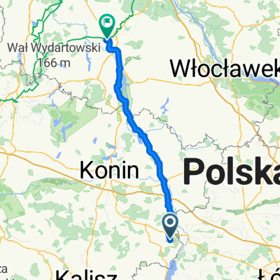
Koło - Licheń - Konin
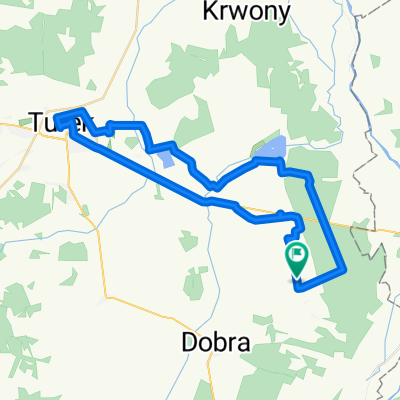
A cycling route starting in Dobra, Greater Poland Voivodeship, Poland.
Overview
About this route
- -:--
- Duration
- 137.6 km
- Distance
- 208 m
- Ascent
- 207 m
- Descent
- ---
- Avg. speed
- ---
- Max. altitude

Route quality
Waytypes & surfaces along the route
Waytypes
Road
60.5 km
(44 %)
Quiet road
38.5 km
(28 %)
Surfaces
Paved
104.6 km
(76 %)
Unpaved
2.8 km
(2 %)
Asphalt
104.6 km
(76 %)
Gravel
2.8 km
(2 %)
Undefined
30.3 km
(22 %)
Continue with Bikemap
Use, edit, or download this cycling route
You would like to ride Koło - Licheń - Konin or customize it for your own trip? Here is what you can do with this Bikemap route:
Free features
- Save this route as favorite or in collections
- Copy & plan your own version of this route
- Split it into stages to create a multi-day tour
- Sync your route with Garmin or Wahoo
Premium features
Free trial for 3 days, or one-time payment. More about Bikemap Premium.
- Navigate this route on iOS & Android
- Export a GPX / KML file of this route
- Create your custom printout (try it for free)
- Download this route for offline navigation
Discover more Premium features.
Get Bikemap PremiumFrom our community
Other popular routes starting in Dobra
 Boleszczyn-Koło-Chełmno-Dąbie-Uniejów
- Distance
- 92.6 km
- Ascent
- 118 m
- Descent
- 115 m
- Location
- Dobra, Greater Poland Voivodeship, Poland
 Koło - Licheń - Konin
- Distance
- 137.6 km
- Ascent
- 208 m
- Descent
- 207 m
- Location
- Dobra, Greater Poland Voivodeship, Poland
 Turek, Władysławów
- Distance
- 64.9 km
- Ascent
- 151 m
- Descent
- 153 m
- Location
- Dobra, Greater Poland Voivodeship, Poland
 Boleszczyn-Wartkowice-Poddębice-J.Jeziorsko
- Distance
- 77.7 km
- Ascent
- 164 m
- Descent
- 164 m
- Location
- Dobra, Greater Poland Voivodeship, Poland
 Z Mateuszem
- Distance
- 45.3 km
- Ascent
- 68 m
- Descent
- 70 m
- Location
- Dobra, Greater Poland Voivodeship, Poland
 Inowrocław
- Distance
- 123 km
- Ascent
- 88 m
- Descent
- 120 m
- Location
- Dobra, Greater Poland Voivodeship, Poland
 Na luzie :)
- Distance
- 43.9 km
- Ascent
- 57 m
- Descent
- 57 m
- Location
- Dobra, Greater Poland Voivodeship, Poland
 Boleszczyn - Radyczyny-Uniejów- Zapora
- Distance
- 50 km
- Ascent
- 82 m
- Descent
- 84 m
- Location
- Dobra, Greater Poland Voivodeship, Poland
Open it in the app