

40 miler
A cycling route starting in Odell, Oregon, United States of America.
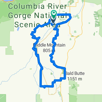
Overview
About this route
- -:--
- Duration
- 51.4 km
- Distance
- 703 m
- Ascent
- 703 m
- Descent
- ---
- Avg. speed
- ---
- Avg. speed

Route quality
Waytypes & surfaces along the route
Waytypes
Busy road
20.3 km
(39 %)
Road
12.4 km
(24 %)
Surfaces
Paved
7 km
(14 %)
Concrete
3.9 km
(8 %)
Asphalt
3 km
(6 %)
Undefined
44.4 km
(86 %)
Continue with Bikemap
Use, edit, or download this cycling route
You would like to ride 40 miler or customize it for your own trip? Here is what you can do with this Bikemap route:
Free features
- Save this route as favorite or in collections
- Copy & plan your own version of this route
- Sync your route with Garmin or Wahoo
Premium features
Free trial for 3 days, or one-time payment. More about Bikemap Premium.
- Navigate this route on iOS & Android
- Export a GPX / KML file of this route
- Create your custom printout (try it for free)
- Download this route for offline navigation
Discover more Premium features.
Get Bikemap PremiumFrom our community
Other popular routes starting in Odell
 Dee-Lost Lake-Parkdale-Dee Loop
- Distance
- 130.8 km
- Ascent
- 2,025 m
- Descent
- 2,025 m
- Location
- Odell, Oregon, United States of America
 40 miler
- Distance
- 51.4 km
- Ascent
- 703 m
- Descent
- 703 m
- Location
- Odell, Oregon, United States of America
 Surveyors Ridge MTB Ride
- Distance
- 37.9 km
- Ascent
- 929 m
- Descent
- 929 m
- Location
- Odell, Oregon, United States of America
 Surveyor's Ridge Epic MTB
- Distance
- 53.5 km
- Ascent
- 1,095 m
- Descent
- 1,095 m
- Location
- Odell, Oregon, United States of America
 (Updated) Fruit Loop -33 miles
- Distance
- 55.6 km
- Ascent
- 1,100 m
- Descent
- 1,018 m
- Location
- Odell, Oregon, United States of America
 3428–3440 Dee Hwy, Hood River to 202 E Historic Columbia River Hwy, Troutdale
- Distance
- 87.5 km
- Ascent
- 1,006 m
- Descent
- 1,246 m
- Location
- Odell, Oregon, United States of America
 7360 Toll Bridge Rd, Mount Hood Parkdale to 7360 Toll Bridge Rd, Mount Hood Parkdale
- Distance
- 0.2 km
- Ascent
- 505 m
- Descent
- 1,010 m
- Location
- Odell, Oregon, United States of America
 6204 Miller Rd, Mount Hood Parkdale to 3773–3799 Gilhouley Rd, Mount Hood Parkdale
- Distance
- 2.1 km
- Ascent
- 19 m
- Descent
- 36 m
- Location
- Odell, Oregon, United States of America
Open it in the app