

Haiger & Umgebung
RR_57km_991hm_Steinbach_HM-Training
A cycling route starting in Haiger, Hesse, Germany.
Overview
About this route
Prima Route um Höhenmeter zu trainieren. Sie führt über Rodenbach, nach Oberroßbach über den Hang (Strava Segment) nach Frohnhausen, dann geht es in Richtung Eibelshausen. Ab Eiershausen beginnt dann ein Epic-Climb 15-20,3% Steigung sind streckenweise zu meistern. Von Hirzenhain geht es dann übers "Hinterland" (Man verzeihe mir den Begriff), über Oberhörlen, Roth und Dietzhölztal dann zurück.
- -:--
- Duration
- 63.4 km
- Distance
- 908 m
- Ascent
- 907 m
- Descent
- ---
- Avg. speed
- ---
- Max. altitude

Part of
11 stages
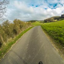
Route photos

Route quality
Waytypes & surfaces along the route
Waytypes
Road
21.5 km
(34 %)
Quiet road
6.3 km
(10 %)
Surfaces
Paved
34.9 km
(55 %)
Unpaved
1.9 km
(3 %)
Asphalt
34.9 km
(55 %)
Gravel
1.9 km
(3 %)
Undefined
26.6 km
(42 %)
Continue with Bikemap
Use, edit, or download this cycling route
You would like to ride RR_57km_991hm_Steinbach_HM-Training or customize it for your own trip? Here is what you can do with this Bikemap route:
Free features
- Save this route as favorite or in collections
- Copy & plan your own version of this route
- Sync your route with Garmin or Wahoo
Premium features
Free trial for 3 days, or one-time payment. More about Bikemap Premium.
- Navigate this route on iOS & Android
- Export a GPX / KML file of this route
- Create your custom printout (try it for free)
- Download this route for offline navigation
Discover more Premium features.
Get Bikemap PremiumFrom our community
Other popular routes starting in Haiger
 HAUBERGSRUNDE
- Distance
- 37.1 km
- Ascent
- 633 m
- Descent
- 576 m
- Location
- Haiger, Hesse, Germany
 Haiger Dillenburg Donsbach
- Distance
- 17.5 km
- Ascent
- 688 m
- Descent
- 775 m
- Location
- Haiger, Hesse, Germany
 Von Haiger nach Wetzlar
- Distance
- 42.2 km
- Ascent
- 246 m
- Descent
- 368 m
- Location
- Haiger, Hesse, Germany
 RR_57km_991hm_Steinbach_HM-Training
- Distance
- 63.4 km
- Ascent
- 908 m
- Descent
- 907 m
- Location
- Haiger, Hesse, Germany
 Karfreitag Gassi-Rad-Tour
- Distance
- 22.2 km
- Ascent
- 460 m
- Descent
- 457 m
- Location
- Haiger, Hesse, Germany
 Dill Lahn Tag1.
- Distance
- 66.4 km
- Ascent
- 160 m
- Descent
- 306 m
- Location
- Haiger, Hesse, Germany
 Entspannende Route in Haiger
- Distance
- 11.3 km
- Ascent
- 179 m
- Descent
- 152 m
- Location
- Haiger, Hesse, Germany
 2013 Runde Roßbachtal Mit Auerhahnhütte
- Distance
- 20.5 km
- Ascent
- 381 m
- Descent
- 381 m
- Location
- Haiger, Hesse, Germany
Open it in the app