

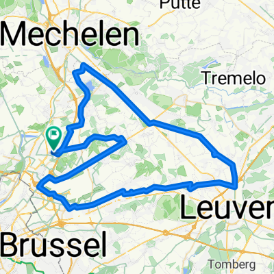
Vaart - HST Route (70K)
A cycling route starting in Vilvoorde, Flemish Region, Belgium.
Overview
About this route
First part of the Vaart route (Mechelen - Leuven - Dijle), then taking the HST route from Leuven to Zaventem, and then a small part again towards Kampenhout to end up with 70K
- -:--
- Duration
- 72.3 km
- Distance
- 77 m
- Ascent
- 77 m
- Descent
- ---
- Avg. speed
- ---
- Max. altitude

Route quality
Waytypes & surfaces along the route
Waytypes
Cycleway
26.7 km
(37 %)
Quiet road
20.2 km
(28 %)
Surfaces
Paved
50.6 km
(70 %)
Asphalt
44.1 km
(61 %)
Concrete
5.8 km
(8 %)
Continue with Bikemap
Use, edit, or download this cycling route
You would like to ride Vaart - HST Route (70K) or customize it for your own trip? Here is what you can do with this Bikemap route:
Free features
- Save this route as favorite or in collections
- Copy & plan your own version of this route
- Sync your route with Garmin or Wahoo
Premium features
Free trial for 3 days, or one-time payment. More about Bikemap Premium.
- Navigate this route on iOS & Android
- Export a GPX / KML file of this route
- Create your custom printout (try it for free)
- Download this route for offline navigation
Discover more Premium features.
Get Bikemap PremiumFrom our community
Other popular routes starting in Vilvoorde
 18.6km
- Distance
- 18.6 km
- Ascent
- 36 m
- Descent
- 36 m
- Location
- Vilvoorde, Flemish Region, Belgium
 brux-antwerp-brux
- Distance
- 98.6 km
- Ascent
- 60 m
- Descent
- 61 m
- Location
- Vilvoorde, Flemish Region, Belgium
 E4 Vilvoorde > Dilbeek
- Distance
- 30.7 km
- Ascent
- 213 m
- Descent
- 154 m
- Location
- Vilvoorde, Flemish Region, Belgium
 20.4km
- Distance
- 19.4 km
- Ascent
- 26 m
- Descent
- 22 m
- Location
- Vilvoorde, Flemish Region, Belgium
 Vaartroute (40K)
- Distance
- 40.3 km
- Ascent
- 38 m
- Descent
- 38 m
- Location
- Vilvoorde, Flemish Region, Belgium
 Vaart - HST Route (70K)
- Distance
- 72.3 km
- Ascent
- 77 m
- Descent
- 77 m
- Location
- Vilvoorde, Flemish Region, Belgium
 Alternative northern loop for Gordel
- Distance
- 30.1 km
- Ascent
- 117 m
- Descent
- 52 m
- Location
- Vilvoorde, Flemish Region, Belgium
 Eddy Merckx Route (80K)
- Distance
- 81.6 km
- Ascent
- 164 m
- Descent
- 165 m
- Location
- Vilvoorde, Flemish Region, Belgium
Open it in the app