

Um Neuenstein
A cycling route starting in Neuenstein, Baden-Wurttemberg, Germany.
Overview
About this route
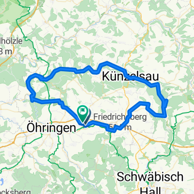
NeuensteinBernhardtsmühle O-Söllbach towards Berghäusle along the forest Kesselfeld Rebbigshof F.hof Neuenstein-home
- -:--
- Duration
- 18.1 km
- Distance
- 163 m
- Ascent
- 165 m
- Descent
- ---
- Avg. speed
- ---
- Max. altitude

Route quality
Waytypes & surfaces along the route
Waytypes
Track
8.7 km
(48 %)
Quiet road
6.2 km
(34 %)
Surfaces
Paved
14 km
(77 %)
Unpaved
1.8 km
(10 %)
Asphalt
11.6 km
(64 %)
Paved (undefined)
2.4 km
(13 %)
Continue with Bikemap
Use, edit, or download this cycling route
You would like to ride Um Neuenstein or customize it for your own trip? Here is what you can do with this Bikemap route:
Free features
- Save this route as favorite or in collections
- Copy & plan your own version of this route
- Sync your route with Garmin or Wahoo
Premium features
Free trial for 3 days, or one-time payment. More about Bikemap Premium.
- Navigate this route on iOS & Android
- Export a GPX / KML file of this route
- Create your custom printout (try it for free)
- Download this route for offline navigation
Discover more Premium features.
Get Bikemap PremiumFrom our community
Other popular routes starting in Neuenstein
 Neuenstein über Kupferzell - Kochertal-bis Ohrnberg
- Distance
- 79.8 km
- Ascent
- 469 m
- Descent
- 473 m
- Location
- Neuenstein, Baden-Wurttemberg, Germany
 Einkauf
- Distance
- 6.3 km
- Ascent
- 62 m
- Descent
- 65 m
- Location
- Neuenstein, Baden-Wurttemberg, Germany
 Zum Breitenauer See
- Distance
- 22.2 km
- Ascent
- 176 m
- Descent
- 247 m
- Location
- Neuenstein, Baden-Wurttemberg, Germany
 Neuenstein-Kochertalroute
- Distance
- 70 km
- Ascent
- 377 m
- Descent
- 377 m
- Location
- Neuenstein, Baden-Wurttemberg, Germany
 Neuenstein zum Limesblick
- Distance
- 16.7 km
- Ascent
- 114 m
- Descent
- 110 m
- Location
- Neuenstein, Baden-Wurttemberg, Germany
 Neuenstein-Hirschhorn
- Distance
- 94.6 km
- Ascent
- 304 m
- Descent
- 463 m
- Location
- Neuenstein, Baden-Wurttemberg, Germany
 Um Neuenstein
- Distance
- 41.6 km
- Ascent
- 284 m
- Descent
- 283 m
- Location
- Neuenstein, Baden-Wurttemberg, Germany
 Kocher-Ohrn-Eppach Radweg
- Distance
- 75 km
- Ascent
- 310 m
- Descent
- 306 m
- Location
- Neuenstein, Baden-Wurttemberg, Germany
Open it in the app