

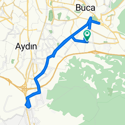
şehir,orman
A cycling route starting in Buca, İzmir Province, Republic of Türkiye.
Overview
About this route
- -:--
- Duration
- 17.6 km
- Distance
- 211 m
- Ascent
- 208 m
- Descent
- ---
- Avg. speed
- ---
- Max. altitude

Continue with Bikemap
Use, edit, or download this cycling route
You would like to ride şehir,orman or customize it for your own trip? Here is what you can do with this Bikemap route:
Free features
- Save this route as favorite or in collections
- Copy & plan your own version of this route
- Sync your route with Garmin or Wahoo
Premium features
Free trial for 3 days, or one-time payment. More about Bikemap Premium.
- Navigate this route on iOS & Android
- Export a GPX / KML file of this route
- Create your custom printout (try it for free)
- Download this route for offline navigation
Discover more Premium features.
Get Bikemap PremiumFrom our community
Other popular routes starting in Buca
 sport touring
- Distance
- 819.6 km
- Ascent
- 11,827 m
- Descent
- 11,802 m
- Location
- Buca, İzmir Province, Republic of Türkiye
 izmir adıyaman turu
- Distance
- 1,311 km
- Ascent
- 4,225 m
- Descent
- 3,573 m
- Location
- Buca, İzmir Province, Republic of Türkiye
 Ruta Turquia 2023 1
- Distance
- 92.5 km
- Ascent
- 1,028 m
- Descent
- 974 m
- Location
- Buca, İzmir Province, Republic of Türkiye
 دوچرخه سواری از مزار شمس تا مولانا (خوی تا قونیه)
- Distance
- 2,983 km
- Ascent
- 6,688 m
- Descent
- 6,643 m
- Location
- Buca, İzmir Province, Republic of Türkiye
 242/27. Sokak 5 A, Buca Osb to 242/27. Sokak 20 B, Buca Osb
- Distance
- 26.2 km
- Ascent
- 323 m
- Descent
- 316 m
- Location
- Buca, İzmir Province, Republic of Türkiye
 Kemalpaşa Caddesi 285/3 naar Kent Tarihi Park İçi Yolu 2
- Distance
- 10.9 km
- Ascent
- 10 m
- Descent
- 78 m
- Location
- Buca, İzmir Province, Republic of Türkiye
 Izmir - Efez
- Distance
- 146.4 km
- Ascent
- 405 m
- Descent
- 414 m
- Location
- Buca, İzmir Province, Republic of Türkiye
 Day 6 p2
- Distance
- 15.8 km
- Ascent
- 294 m
- Descent
- 240 m
- Location
- Buca, İzmir Province, Republic of Türkiye
Open it in the app