

Soisberg_LangeSteine_RuineHauneck
A cycling route starting in Bad Hersfeld, Hesse, Germany.
Overview
About this route
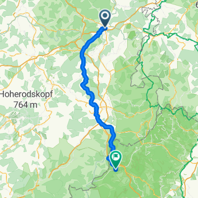
The route goes along the R7/Solztalradweg to Schenklengsfeld, then climbs up to the Soisberg Tower. Near Wenigentaft, by the Buchenmühle (Beech Mill), it follows the Kegelspielradweg cycling path to Steinbach. Here, you can take a short break at the Café Alter Bahnhof by the Kegelspielradweg before ascending to Unterstoppel towards the Langen Steinen, then on to Oberstoppel at the Hauneck castle ruins. Afterwards, it descends into the Haune valley on the Haunetalradweg, passes through Bad Hersfeld by the Fulda lake, and finally returns to the starting point.
- -:--
- Duration
- 79.8 km
- Distance
- 684 m
- Ascent
- 681 m
- Descent
- ---
- Avg. speed
- ---
- Max. altitude
Route quality
Waytypes & surfaces along the route
Waytypes
Track
35.1 km
(44 %)
Path
20.7 km
(26 %)
Surfaces
Paved
51.9 km
(65 %)
Unpaved
22.3 km
(28 %)
Asphalt
44.7 km
(56 %)
Gravel
19.2 km
(24 %)
Route highlights
Points of interest along the route
Drinking water after 4.5 km
Biergarten Zum Alten Bahnhof
Point of interest after 22.5 km
Soisbergturm
Drinking water after 47.1 km
Café Alter Bahnhof
Point of interest after 53.9 km
Lange Steine
Point of interest after 56.6 km
Burgruine Hauneck
Continue with Bikemap
Use, edit, or download this cycling route
You would like to ride Soisberg_LangeSteine_RuineHauneck or customize it for your own trip? Here is what you can do with this Bikemap route:
Free features
- Save this route as favorite or in collections
- Copy & plan your own version of this route
- Sync your route with Garmin or Wahoo
Premium features
Free trial for 3 days, or one-time payment. More about Bikemap Premium.
- Navigate this route on iOS & Android
- Export a GPX / KML file of this route
- Create your custom printout (try it for free)
- Download this route for offline navigation
Discover more Premium features.
Get Bikemap PremiumFrom our community
Other popular routes starting in Bad Hersfeld
 Seulingswald3
- Distance
- 60.2 km
- Ascent
- 645 m
- Descent
- 645 m
- Location
- Bad Hersfeld, Hesse, Germany
 Fulda Eichenzell
- Distance
- 92 km
- Ascent
- 1,080 m
- Descent
- 920 m
- Location
- Bad Hersfeld, Hesse, Germany
 Kleine Runde im Fuldatal
- Distance
- 40.9 km
- Ascent
- 153 m
- Descent
- 154 m
- Location
- Bad Hersfeld, Hesse, Germany
 Bad Homburg - Hamburg Teil 2
- Distance
- 138.3 km
- Ascent
- 431 m
- Descent
- 478 m
- Location
- Bad Hersfeld, Hesse, Germany
 Solztal - Eiterfeld - Burghaun (Biergarten)
- Distance
- 60.2 km
- Ascent
- 269 m
- Descent
- 331 m
- Location
- Bad Hersfeld, Hesse, Germany
 Soisberg_LangeSteine_RuineHauneck
- Distance
- 79.8 km
- Ascent
- 684 m
- Descent
- 681 m
- Location
- Bad Hersfeld, Hesse, Germany
 Bad Hersfeld - Haunetal
- Distance
- 51.4 km
- Ascent
- 300 m
- Descent
- 300 m
- Location
- Bad Hersfeld, Hesse, Germany
 De Glockenstraße 14, Bad Hersfeld a Glockenstraße 14, Bad Hersfeld
- Distance
- 15.9 km
- Ascent
- 255 m
- Descent
- 307 m
- Location
- Bad Hersfeld, Hesse, Germany
Open it in the app