

Frauenbründl-Saalhaupt
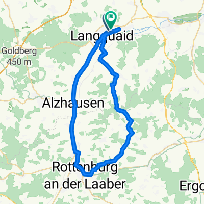
A cycling route starting in Langquaid, Bavaria, Germany.
Overview
About this route
Dietenhofen
Stocka
Teugn
Frauenbründl
Saalhaupt
Oberschneidhart
Grub
- -:--
- Duration
- 29.6 km
- Distance
- 411 m
- Ascent
- 409 m
- Descent
- ---
- Avg. speed
- ---
- Max. altitude

Route quality
Waytypes & surfaces along the route
Waytypes
Track
20.1 km
(68 %)
Road
4.4 km
(15 %)
Surfaces
Paved
8 km
(27 %)
Unpaved
17.2 km
(58 %)
Gravel
8.3 km
(28 %)
Asphalt
6.5 km
(22 %)
Continue with Bikemap
Use, edit, or download this cycling route
You would like to ride Frauenbründl-Saalhaupt or customize it for your own trip? Here is what you can do with this Bikemap route:
Free features
- Save this route as favorite or in collections
- Copy & plan your own version of this route
- Sync your route with Garmin or Wahoo
Premium features
Free trial for 3 days, or one-time payment. More about Bikemap Premium.
- Navigate this route on iOS & Android
- Export a GPX / KML file of this route
- Create your custom printout (try it for free)
- Download this route for offline navigation
Discover more Premium features.
Get Bikemap PremiumFrom our community
Other popular routes starting in Langquaid
 Frauenbründl-Saalhaupt
- Distance
- 29.6 km
- Ascent
- 411 m
- Descent
- 409 m
- Location
- Langquaid, Bavaria, Germany
 ForstnerWirt Runde MTB
- Distance
- 38.5 km
- Ascent
- 314 m
- Descent
- 315 m
- Location
- Langquaid, Bavaria, Germany
 Handewerkerhof 12, Langquaid nach Handewerkerhof 12, Langquaid
- Distance
- 35.8 km
- Ascent
- 1,350 m
- Descent
- 1,348 m
- Location
- Langquaid, Bavaria, Germany
 2018.05.02_MTB-Herren_Obermassing
- Distance
- 42 km
- Ascent
- 428 m
- Descent
- 428 m
- Location
- Langquaid, Bavaria, Germany
 2020-08-08_Kanonenrohr
- Distance
- 30.2 km
- Ascent
- 343 m
- Descent
- 342 m
- Location
- Langquaid, Bavaria, Germany
 20170414_Karfreitagsrunde zum Frauenhäusl mit Annemarie
- Distance
- 52 km
- Ascent
- 434 m
- Descent
- 434 m
- Location
- Langquaid, Bavaria, Germany
 Winkl-Oberhaselbach-Mannsdorf
- Distance
- 42.3 km
- Ascent
- 502 m
- Descent
- 500 m
- Location
- Langquaid, Bavaria, Germany
 2016.07.10_Gruppe 2_Forst Sinsbuch-Obereichet-Kiesgrube
- Distance
- 22.9 km
- Ascent
- 220 m
- Descent
- 219 m
- Location
- Langquaid, Bavaria, Germany
Open it in the app