

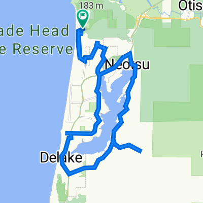
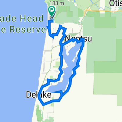
Day 2
A cycling route starting in Lincoln City, Oregon, United States.
Overview
About this route
Stating at the Lincoln City KOA 800-562-3316
- -:--
- Duration
- 63.6 km
- Distance
- 706 m
- Ascent
- 638 m
- Descent
- ---
- Avg. speed
- ---
- Max. altitude
Route quality
Waytypes & surfaces along the route
Waytypes
Cycleway
22.9 km
(36 %)
Road
19.1 km
(30 %)
Surfaces
Paved
17.2 km
(27 %)
Asphalt
15.3 km
(24 %)
Paved (undefined)
1.9 km
(3 %)
Undefined
46.5 km
(73 %)
Continue with Bikemap
Use, edit, or download this cycling route
You would like to ride Day 2 or customize it for your own trip? Here is what you can do with this Bikemap route:
Free features
- Save this route as favorite or in collections
- Copy & plan your own version of this route
- Sync your route with Garmin or Wahoo
Premium features
Free trial for 3 days, or one-time payment. More about Bikemap Premium.
- Navigate this route on iOS & Android
- Export a GPX / KML file of this route
- Create your custom printout (try it for free)
- Download this route for offline navigation
Discover more Premium features.
Get Bikemap PremiumFrom our community
Other popular routes starting in Lincoln City
 Lincoln City to Florence Oregon
- Distance
- 124.4 km
- Ascent
- 588 m
- Descent
- 592 m
- Location
- Lincoln City, Oregon, United States
 U.S. 101 3510, Lincoln City to Northeast Highway 101 3910, Lincoln City
- Distance
- 5.1 km
- Ascent
- 42 m
- Descent
- 38 m
- Location
- Lincoln City, Oregon, United States
 6976 NE Neptune Dr, Lincoln City to 6969 NE Neptune Dr, Lincoln City
- Distance
- 27.7 km
- Ascent
- 555 m
- Descent
- 555 m
- Location
- Lincoln City, Oregon, United States
 Southeast Jetty Avenue 606, Lincoln City to U.S. 101 4439, Lincoln City
- Distance
- 3.8 km
- Ascent
- 34 m
- Descent
- 32 m
- Location
- Lincoln City, Oregon, United States
 6800 NE Neptune Dr, Lincoln City to 6969 NE Neptune Dr, Lincoln City
- Distance
- 24.5 km
- Ascent
- 468 m
- Descent
- 441 m
- Location
- Lincoln City, Oregon, United States
 Day 4 - Devil’s Lake to Newport
- Distance
- 42.5 km
- Ascent
- 586 m
- Descent
- 550 m
- Location
- Lincoln City, Oregon, United States
 1935 NE 69th St, Lincoln City to 6969 NE Neptune Dr, Lincoln City
- Distance
- 28.3 km
- Ascent
- 461 m
- Descent
- 477 m
- Location
- Lincoln City, Oregon, United States
 6976 NE Neptune Dr, Lincoln City to 6969 NE Neptune Dr, Lincoln City
- Distance
- 23.1 km
- Ascent
- 388 m
- Descent
- 392 m
- Location
- Lincoln City, Oregon, United States
Open it in the app