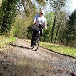
Rosbach_Friedberg _Bad_Nauheim
A cycling route starting in Rosbach vor der Höhe, Hesse, Germany.
Overview
About this route
As a starting point, the train station in Rosbach was chosen. Here, you can either park your car or easily arrive with the HLB line 16, but you can also start the round tour at other locations. In Rosbach, for example, the hiking parking lot below the Rosenkranzhecken bridge is suitable for this.
The route leads through Rosbach, Ockstadt, Bad Nauheim, and Friedberg, and in all four places there are options to stop for refreshments.
In the area of the Friedberg Seewiese, the signage is a bit 'confusing', or rather absent, but parallel to the playground there is also a bike path next to the footpath, which then winds a bit 'tricky' through a school, hotel, and parking area after the Seewiese, before continuing on the Äppelwoiweg towards Ockstadt.
For an alternative route back through Ockstadt, it goes through the town center, up to a golf course area, and from there, via a reasonably well-maintained forest path, through the Löwenhof settlement, returning to Oberrosbach.
- -:--
- Duration
- 25.1 km
- Distance
- 150 m
- Ascent
- 148 m
- Descent
- ---
- Avg. speed
- ---
- Max. altitude
Route photos
Route quality
Waytypes & surfaces along the route
Waytypes
Track
13.3 km
(53 %)
Quiet road
7 km
(28 %)
Surfaces
Paved
16.1 km
(64 %)
Unpaved
5.5 km
(22 %)
Asphalt
13.6 km
(54 %)
Gravel
3.3 km
(13 %)
Continue with Bikemap
Use, edit, or download this cycling route
You would like to ride Rosbach_Friedberg _Bad_Nauheim or customize it for your own trip? Here is what you can do with this Bikemap route:
Free features
- Save this route as favorite or in collections
- Copy & plan your own version of this route
- Sync your route with Garmin or Wahoo
Premium features
Free trial for 3 days, or one-time payment. More about Bikemap Premium.
- Navigate this route on iOS & Android
- Export a GPX / KML file of this route
- Create your custom printout (try it for free)
- Download this route for offline navigation
Discover more Premium features.
Get Bikemap PremiumFrom our community
Other popular routes starting in Rosbach vor der Höhe
 Laufrunde
- Distance
- 5.6 km
- Ascent
- 37 m
- Descent
- 30 m
- Location
- Rosbach vor der Höhe, Hesse, Germany
 Binx3_UsingerStr.,TS-Wetterau_T_via TS Wetterau,WintersteinStr, SchmurStr...
- Distance
- 6.3 km
- Ascent
- 66 m
- Descent
- 138 m
- Location
- Rosbach vor der Höhe, Hesse, Germany
 Mai Tour 40km
- Distance
- 40.6 km
- Ascent
- 150 m
- Descent
- 150 m
- Location
- Rosbach vor der Höhe, Hesse, Germany
 RTF Rodheim
- Distance
- 106.1 km
- Ascent
- 1,423 m
- Descent
- 1,423 m
- Location
- Rosbach vor der Höhe, Hesse, Germany
 Rund Burgholzhausen
- Distance
- 17.1 km
- Ascent
- 127 m
- Descent
- 129 m
- Location
- Rosbach vor der Höhe, Hesse, Germany
 Rund um Bad Nauheim und Friedberg
- Distance
- 42.6 km
- Ascent
- 282 m
- Descent
- 287 m
- Location
- Rosbach vor der Höhe, Hesse, Germany
 Rosbach, Ober Erlenbach, Rosbach
- Distance
- 26.2 km
- Ascent
- 299 m
- Descent
- 302 m
- Location
- Rosbach vor der Höhe, Hesse, Germany
 RTF VC Frankfurt (111)
- Distance
- 115.5 km
- Ascent
- 1,930 m
- Descent
- 1,812 m
- Location
- Rosbach vor der Höhe, Hesse, Germany
Open it in the app


