

Verkenning Bastenaken
A cycling route starting in Ferrières, Wallonia, Belgium.
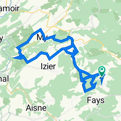
Overview
About this route
Departure and arrival in Werbomont
Pick-up just behind Durbuy up to behind Stoumont
- -:--
- Duration
- 151.2 km
- Distance
- 1,092 m
- Ascent
- 1,101 m
- Descent
- ---
- Avg. speed
- ---
- Max. altitude

Route quality
Waytypes & surfaces along the route
Waytypes
Road
28.7 km
(19 %)
Quiet road
27.2 km
(18 %)
Surfaces
Paved
84.7 km
(56 %)
Unpaved
3 km
(2 %)
Asphalt
84.7 km
(56 %)
Unpaved (undefined)
1.5 km
(1 %)
Continue with Bikemap
Use, edit, or download this cycling route
You would like to ride Verkenning Bastenaken or customize it for your own trip? Here is what you can do with this Bikemap route:
Free features
- Save this route as favorite or in collections
- Copy & plan your own version of this route
- Split it into stages to create a multi-day tour
- Sync your route with Garmin or Wahoo
Premium features
Free trial for 3 days, or one-time payment. More about Bikemap Premium.
- Navigate this route on iOS & Android
- Export a GPX / KML file of this route
- Create your custom printout (try it for free)
- Download this route for offline navigation
Discover more Premium features.
Get Bikemap PremiumFrom our community
Other popular routes starting in Ferrières
 Rue du Burnontige 20B, Ferrières naar Rue du Burnontige 20B, Ferrières
- Distance
- 30.8 km
- Ascent
- 612 m
- Descent
- 612 m
- Location
- Ferrières, Wallonia, Belgium
 Rue du Burnontige 20B, Ferrières naar Rue du Burnontige 20B, Ferrières
- Distance
- 31.1 km
- Ascent
- 729 m
- Descent
- 722 m
- Location
- Ferrières, Wallonia, Belgium
 Werbomont - Werbomont
- Distance
- 78.3 km
- Ascent
- 1,557 m
- Descent
- 1,557 m
- Location
- Ferrières, Wallonia, Belgium
 Stavelot - Malmedy - Baraque Michel - Spa - Aywalle
- Distance
- 107.8 km
- Ascent
- 1,256 m
- Descent
- 1,256 m
- Location
- Ferrières, Wallonia, Belgium
 Ferrières - ozo - Villers
- Distance
- 17.7 km
- Ascent
- 338 m
- Descent
- 328 m
- Location
- Ferrières, Wallonia, Belgium
 Zwischenetappe
- Distance
- 66.8 km
- Ascent
- 1,187 m
- Descent
- 1,246 m
- Location
- Ferrières, Wallonia, Belgium
 Werbomont Ferrieres Ernonheid
- Distance
- 22.5 km
- Ascent
- 505 m
- Descent
- 506 m
- Location
- Ferrières, Wallonia, Belgium
 Rondje Bois de Weris
- Distance
- 36.5 km
- Ascent
- 540 m
- Descent
- 540 m
- Location
- Ferrières, Wallonia, Belgium
Open it in the app