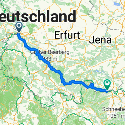
Werratal: Hörschel nach Hann. Münden
A cycling route starting in Krauthausen, Thuringia, Germany.
Overview
About this route
- -:--
- Duration
- 110 km
- Distance
- 227 m
- Ascent
- 300 m
- Descent
- ---
- Avg. speed
- ---
- Max. altitude
Route quality
Waytypes & surfaces along the route
Waytypes
Track
38.5 km
(35 %)
Quiet road
29.7 km
(27 %)
Surfaces
Paved
88.1 km
(80 %)
Unpaved
16.3 km
(15 %)
Asphalt
75 km
(68 %)
Gravel
9.8 km
(9 %)
Continue with Bikemap
Use, edit, or download this cycling route
You would like to ride Werratal: Hörschel nach Hann. Münden or customize it for your own trip? Here is what you can do with this Bikemap route:
Free features
- Save this route as favorite or in collections
- Copy & plan your own version of this route
- Split it into stages to create a multi-day tour
- Sync your route with Garmin or Wahoo
Premium features
Free trial for 3 days, or one-time payment. More about Bikemap Premium.
- Navigate this route on iOS & Android
- Export a GPX / KML file of this route
- Create your custom printout (try it for free)
- Download this route for offline navigation
Discover more Premium features.
Get Bikemap PremiumFrom our community
Other popular routes starting in Krauthausen
- Rennsteig Radweg
- Distance
- 197.5 km
- Ascent
- 1,466 m
- Descent
- 1,237 m
- Location
- Krauthausen, Thuringia, Germany
- Trans-Thüringerwald
- Distance
- 186 km
- Ascent
- 2,050 m
- Descent
- 1,757 m
- Location
- Krauthausen, Thuringia, Germany
- rennsteg
- Distance
- 67.2 km
- Ascent
- 1,158 m
- Descent
- 595 m
- Location
- Krauthausen, Thuringia, Germany
- Mühlgasse 8, Krauthausen nach Mühlgasse 8, Krauthausen
- Distance
- 27.7 km
- Ascent
- 429 m
- Descent
- 435 m
- Location
- Krauthausen, Thuringia, Germany
- Rennsteig die 2. Hörschel-Masserberg
- Distance
- 99.9 km
- Ascent
- 1,365 m
- Descent
- 779 m
- Location
- Krauthausen, Thuringia, Germany
- Hainich-Baude-1
- Distance
- 62.7 km
- Ascent
- 579 m
- Descent
- 579 m
- Location
- Krauthausen, Thuringia, Germany
- Rennsteig Thüringer Wald
- Distance
- 193.1 km
- Ascent
- 1,451 m
- Descent
- 1,247 m
- Location
- Krauthausen, Thuringia, Germany
- Rennsteigtour
- Distance
- 184.3 km
- Ascent
- 1,341 m
- Descent
- 1,119 m
- Location
- Krauthausen, Thuringia, Germany
Open it in the app