

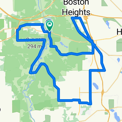
Lock 29 East Ridge Ride
A cycling route starting in Peninsula, Ohio, United States.
Overview
About this route
Includes two lengthy hills with easy-to-moderate grades, a nice stretch on paved bike path and a long, fast and easy stretch home.
- -:--
- Duration
- 43.9 km
- Distance
- 281 m
- Ascent
- 281 m
- Descent
- ---
- Avg. speed
- ---
- Max. altitude

Route quality
Waytypes & surfaces along the route
Waytypes
Road
25 km
(57 %)
Cycleway
8.3 km
(19 %)
Surfaces
Paved
19.8 km
(45 %)
Asphalt
18 km
(41 %)
Paved (undefined)
1.3 km
(3 %)
Continue with Bikemap
Use, edit, or download this cycling route
You would like to ride Lock 29 East Ridge Ride or customize it for your own trip? Here is what you can do with this Bikemap route:
Free features
- Save this route as favorite or in collections
- Copy & plan your own version of this route
- Sync your route with Garmin or Wahoo
Premium features
Free trial for 3 days, or one-time payment. More about Bikemap Premium.
- Navigate this route on iOS & Android
- Export a GPX / KML file of this route
- Create your custom printout (try it for free)
- Download this route for offline navigation
Discover more Premium features.
Get Bikemap PremiumFrom our community
Other popular routes starting in Peninsula
 CVNP Major Rd climb
- Distance
- 4.5 km
- Ascent
- 78 m
- Descent
- 10 m
- Location
- Peninsula, Ohio, United States
 Deep Lock - Berea
- Distance
- 77.3 km
- Ascent
- 632 m
- Descent
- 608 m
- Location
- Peninsula, Ohio, United States
 Lock 29 East Ridge Ride
- Distance
- 43.9 km
- Ascent
- 281 m
- Descent
- 281 m
- Location
- Peninsula, Ohio, United States
 Canal Exploration Center and Back
- Distance
- 19.6 km
- Ascent
- 92 m
- Descent
- 116 m
- Location
- Peninsula, Ohio, United States
 48K TWO-HILL LOOP
- Distance
- 47.9 km
- Ascent
- 297 m
- Descent
- 292 m
- Location
- Peninsula, Ohio, United States
 Peninsula to BW Falls
- Distance
- 7.4 km
- Ascent
- 120 m
- Descent
- 65 m
- Location
- Peninsula, Ohio, United States
 Moderate route in Peninsula
- Distance
- 63.8 km
- Ascent
- 362 m
- Descent
- 362 m
- Location
- Peninsula, Ohio, United States
 Peninsula South (and Return)
- Distance
- 17.2 km
- Ascent
- 118 m
- Descent
- 110 m
- Location
- Peninsula, Ohio, United States
Open it in the app