

Rückenbesserungstour 27.04.18
A cycling route starting in Mainzweiler, Saarland, Germany.
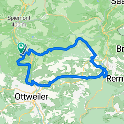
Overview
About this route
gefahren am 27.4.18; Zeit 0:54h; Schnitt 15,7km/h Wetter sonnig 13°C; Probetour mit Rückenleiden
- -:--
- Duration
- 14.2 km
- Distance
- 189 m
- Ascent
- 189 m
- Descent
- ---
- Avg. speed
- ---
- Max. altitude
Route quality
Waytypes & surfaces along the route
Waytypes
Quiet road
5 km
(35 %)
Track
4.6 km
(32 %)
Surfaces
Paved
4.1 km
(29 %)
Unpaved
3.4 km
(24 %)
Paved (undefined)
2.4 km
(17 %)
Gravel
1.9 km
(13 %)
Continue with Bikemap
Use, edit, or download this cycling route
You would like to ride Rückenbesserungstour 27.04.18 or customize it for your own trip? Here is what you can do with this Bikemap route:
Free features
- Save this route as favorite or in collections
- Copy & plan your own version of this route
- Sync your route with Garmin or Wahoo
Premium features
Free trial for 3 days, or one-time payment. More about Bikemap Premium.
- Navigate this route on iOS & Android
- Export a GPX / KML file of this route
- Create your custom printout (try it for free)
- Download this route for offline navigation
Discover more Premium features.
Get Bikemap PremiumFrom our community
Other popular routes starting in Mainzweiler
 Mainzweiler-Biberweg-Rheinstrasse- Mainzweiler
- Distance
- 29.4 km
- Ascent
- 444 m
- Descent
- 491 m
- Location
- Mainzweiler, Saarland, Germany
 kurze Morgenrunde 16.11.17
- Distance
- 19.9 km
- Ascent
- 347 m
- Descent
- 339 m
- Location
- Mainzweiler, Saarland, Germany
 Holzschilder Tour 5 15.8.17
- Distance
- 19.8 km
- Ascent
- 340 m
- Descent
- 340 m
- Location
- Mainzweiler, Saarland, Germany
 Genussradeln-Tour 29.4.18
- Distance
- 24.9 km
- Ascent
- 379 m
- Descent
- 381 m
- Location
- Mainzweiler, Saarland, Germany
 Schnelle Seetour 1.7.18
- Distance
- 62.5 km
- Ascent
- 567 m
- Descent
- 560 m
- Location
- Mainzweiler, Saarland, Germany
 Remmesweiler Saarbrücken über Hüttigweiler Fischbach
- Distance
- 42.1 km
- Ascent
- 828 m
- Descent
- 905 m
- Location
- Mainzweiler, Saarland, Germany
 WND Wendalinum-Park mit dem Mountainbike
- Distance
- 42.5 km
- Ascent
- 334 m
- Descent
- 334 m
- Location
- Mainzweiler, Saarland, Germany
 Tacho-Such-Tour 24.7.18
- Distance
- 19.3 km
- Ascent
- 372 m
- Descent
- 373 m
- Location
- Mainzweiler, Saarland, Germany
Open it in the app