

tol makadam
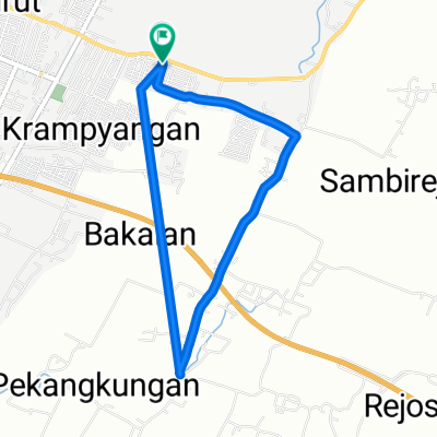
A cycling route starting in Pasuruan, East Java, Indonesia.
Overview
About this route
- 1 h 30 min
- Duration
- 21.4 km
- Distance
- 235 m
- Ascent
- 218 m
- Descent
- 14.2 km/h
- Avg. speed
- ---
- Max. altitude

Route photos

Continue with Bikemap
Use, edit, or download this cycling route
You would like to ride tol makadam or customize it for your own trip? Here is what you can do with this Bikemap route:
Free features
- Save this route as favorite or in collections
- Copy & plan your own version of this route
- Sync your route with Garmin or Wahoo
Premium features
Free trial for 3 days, or one-time payment. More about Bikemap Premium.
- Navigate this route on iOS & Android
- Export a GPX / KML file of this route
- Create your custom printout (try it for free)
- Download this route for offline navigation
Discover more Premium features.
Get Bikemap PremiumFrom our community
Other popular routes starting in Pasuruan
 tol pas
- Distance
- 12.9 km
- Ascent
- 182 m
- Descent
- 179 m
- Location
- Pasuruan, East Java, Indonesia
 Gowes
Gowes- Distance
- 13 km
- Ascent
- 48 m
- Descent
- 20 m
- Location
- Pasuruan, East Java, Indonesia
 240418
- Distance
- 5.6 km
- Ascent
- 35 m
- Descent
- 38 m
- Location
- Pasuruan, East Java, Indonesia
 Jalan Darmoyudo A 45, Kecamatan Purworejo to Jalan komodor Yos Sudarso No.99, Panggungrejo
- Distance
- 2.9 km
- Ascent
- 0 m
- Descent
- 5 m
- Location
- Pasuruan, East Java, Indonesia
 tol makadam
- Distance
- 21.4 km
- Ascent
- 235 m
- Descent
- 218 m
- Location
- Pasuruan, East Java, Indonesia
 Sumatra-Java-Bali 22, Indonesien, Pasuruan - Wonokitri, 43 km
- Distance
- 42.8 km
- Ascent
- 1,872 m
- Descent
- 6 m
- Location
- Pasuruan, East Java, Indonesia
 pasaruan - via noordkust naar de pont
- Distance
- 236.4 km
- Ascent
- 386 m
- Descent
- 389 m
- Location
- Pasuruan, East Java, Indonesia
 My First 1000km
- Distance
- 444 km
- Ascent
- 1,876 m
- Descent
- 1,853 m
- Location
- Pasuruan, East Java, Indonesia
Open it in the app