

Hornberger Felsentrail
A cycling route starting in Hornberg, Baden-Wurttemberg, Germany.
Overview
About this route
Description:
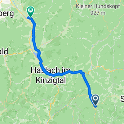
The start is at the parking lot 'Am Läuterberg' or directly at the railway viaduct. From there, you pass by the train station, then turn left over the tracks. Follow the road uphill for about 100 m and then turn right onto W. Hausenstein-Str. Climb a serpentine and then don’t miss the trail entrance (diamond). From here, the trail ascends along a rocky, sometimes narrow, and not entirely safe path (caution in wet conditions!). At the locality 'Am Rubersbach', you briefly ride on a forestry road or asphalt. At the top of the road, re-enter the trail and continue climbing to 'Bertaquelle'. A great pause stop and an opportunity to enjoy fresh spring water. From here, you continue on forestry roads with some great views over Hornberg heading towards 'Windeckhütte'. Here, at the highest point of the tour, it’s worth climbing to the viewpoint rock. From now on, it’s down a nice trail with a few switchbacks. You’re back down way too quickly. Then you roll back to Hornberg. In the town, you can find good places to eat!
- -:--
- Duration
- 12.2 km
- Distance
- 619 m
- Ascent
- 621 m
- Descent
- ---
- Avg. speed
- ---
- Max. altitude

Continue with Bikemap
Use, edit, or download this cycling route
You would like to ride Hornberger Felsentrail or customize it for your own trip? Here is what you can do with this Bikemap route:
Free features
- Save this route as favorite or in collections
- Copy & plan your own version of this route
- Sync your route with Garmin or Wahoo
Premium features
Free trial for 3 days, or one-time payment. More about Bikemap Premium.
- Navigate this route on iOS & Android
- Export a GPX / KML file of this route
- Create your custom printout (try it for free)
- Download this route for offline navigation
Discover more Premium features.
Get Bikemap PremiumFrom our community
Other popular routes starting in Hornberg
 Felsentrail Hornberg
- Distance
- 12.2 km
- Ascent
- 617 m
- Descent
- 619 m
- Location
- Hornberg, Baden-Wurttemberg, Germany
 Hornberg Hockenheim
- Distance
- 173.4 km
- Ascent
- 641 m
- Descent
- 920 m
- Location
- Hornberg, Baden-Wurttemberg, Germany
 Hornberg nach Gengenbach
- Distance
- 66.8 km
- Ascent
- 257 m
- Descent
- 452 m
- Location
- Hornberg, Baden-Wurttemberg, Germany
 Rundweg Hornberg - Triberg
- Distance
- 39.3 km
- Ascent
- 786 m
- Descent
- 786 m
- Location
- Hornberg, Baden-Wurttemberg, Germany
 Hornberg-Schondelhöhe
- Distance
- 5.8 km
- Ascent
- 570 m
- Descent
- 169 m
- Location
- Hornberg, Baden-Wurttemberg, Germany
 Hornberg-Sindelfingen
- Distance
- 104.8 km
- Ascent
- 940 m
- Descent
- 912 m
- Location
- Hornberg, Baden-Wurttemberg, Germany
 2009-09-01 Hornberg - Zell
- Distance
- 28.9 km
- Ascent
- 296 m
- Descent
- 510 m
- Location
- Hornberg, Baden-Wurttemberg, Germany
 MTB Hornberger Stadtwald
- Distance
- 11.5 km
- Ascent
- 704 m
- Descent
- 685 m
- Location
- Hornberg, Baden-Wurttemberg, Germany
Open it in the app