
Overview
About this route
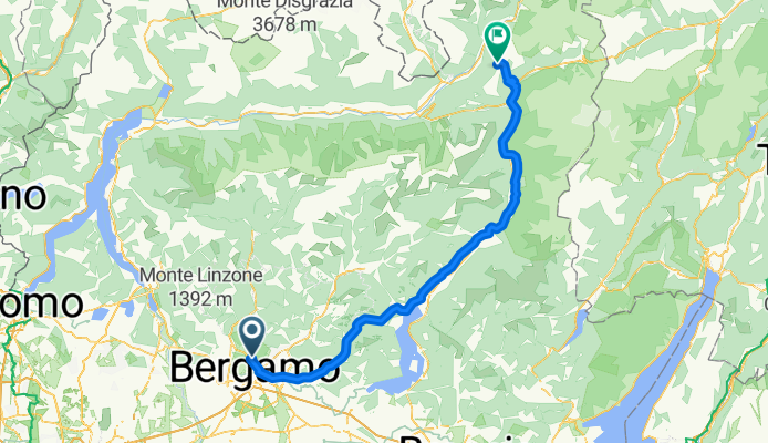
Bergamo - Monno (BS)
Passo del Mortirolo
- -:--
- Duration
- 117.8 km
- Distance
- 1,871 m
- Ascent
- 289 m
- Descent
- ---
- Avg. speed
- ---
- Max. altitude

Part of

Tour 2018
5 stages
Route quality
Waytypes & surfaces along the route
Waytypes
Road
21.2 km
(18 %)
Quiet road
13 km
(11 %)
Surfaces
Paved
100.1 km
(85 %)
Asphalt
100.1 km
(85 %)
Undefined
17.7 km
(15 %)
Continue with Bikemap
Use, edit, or download this cycling route
You would like to ride 1^ tappa viaggio 2018 or customize it for your own trip? Here is what you can do with this Bikemap route:
Free features
- Save this route as favorite or in collections
- Copy & plan your own version of this route
- Split it into stages to create a multi-day tour
- Sync your route with Garmin or Wahoo
Premium features
Free trial for 3 days, or one-time payment. More about Bikemap Premium.
- Navigate this route on iOS & Android
- Export a GPX / KML file of this route
- Create your custom printout (try it for free)
- Download this route for offline navigation
Discover more Premium features.
Get Bikemap PremiumFrom our community
Other popular routes starting in Ponteranica
 Alpi
Alpi- Distance
- 743 km
- Ascent
- 3,027 m
- Descent
- 3,027 m
- Location
- Ponteranica, Lombardy, Italy
 Brembilla - Cornalita - Buco del Ratto
- Distance
- 61.5 km
- Ascent
- 521 m
- Descent
- 560 m
- Location
- Ponteranica, Lombardy, Italy
 Callameri - Foppe - Valborgo
- Distance
- 63.9 km
- Ascent
- 609 m
- Descent
- 686 m
- Location
- Ponteranica, Lombardy, Italy
 Viaggio in bici 2018
- Distance
- 471.6 km
- Ascent
- 6,853 m
- Descent
- 6,853 m
- Location
- Ponteranica, Lombardy, Italy
 Culmine di S. Pietro - Valcava
- Distance
- 121.5 km
- Ascent
- 2,365 m
- Descent
- 2,366 m
- Location
- Ponteranica, Lombardy, Italy
 Passo della Presolana
- Distance
- 71.2 km
- Ascent
- 1,215 m
- Descent
- 1,061 m
- Location
- Ponteranica, Lombardy, Italy
 giretto
- Distance
- 17.7 km
- Ascent
- 448 m
- Descent
- 448 m
- Location
- Ponteranica, Lombardy, Italy
 Lago d'Endine - Lago d'Iseo
- Distance
- 93.5 km
- Ascent
- 476 m
- Descent
- 476 m
- Location
- Ponteranica, Lombardy, Italy
Open it in the app