

Automne 2018 Ardèche Vals-les-Bains
Antraigues-sur-Volane, Château de Crau
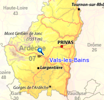
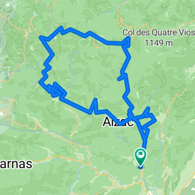
A cycling route starting in Vals-les-Bains, Auvergne-Rhône-Alpes, France.
Overview
About this route
Route for the fourth day (rest)
- -:--
- Duration
- 37.5 km
- Distance
- 798 m
- Ascent
- 794 m
- Descent
- ---
- Avg. speed
- ---
- Max. altitude

Part of
Route quality
Waytypes & surfaces along the route
Waytypes
Road
17.6 km
(47 %)
Quiet road
4.9 km
(13 %)
Surfaces
Paved
28.2 km
(75 %)
Asphalt
28.2 km
(75 %)
Undefined
9.4 km
(25 %)
Continue with Bikemap
Use, edit, or download this cycling route
You would like to ride Antraigues-sur-Volane, Château de Crau or customize it for your own trip? Here is what you can do with this Bikemap route:
Free features
- Save this route as favorite or in collections
- Copy & plan your own version of this route
- Sync your route with Garmin or Wahoo
Premium features
Free trial for 3 days, or one-time payment. More about Bikemap Premium.
- Navigate this route on iOS & Android
- Export a GPX / KML file of this route
- Create your custom printout (try it for free)
- Download this route for offline navigation
Discover more Premium features.
Get Bikemap PremiumFrom our community
Other popular routes starting in Vals-les-Bains
 Antraigues-sur-Volane, Château de Crau
- Distance
- 37.5 km
- Ascent
- 798 m
- Descent
- 794 m
- Location
- Vals-les-Bains, Auvergne-Rhône-Alpes, France
 Jour 2 Ardèche version b
- Distance
- 61.7 km
- Ascent
- 1,484 m
- Descent
- 855 m
- Location
- Vals-les-Bains, Auvergne-Rhône-Alpes, France
 Boucle des 4 vallées
- Distance
- 79.5 km
- Ascent
- 1,541 m
- Descent
- 1,537 m
- Location
- Vals-les-Bains, Auvergne-Rhône-Alpes, France
 Les 2 vallées
- Distance
- 22.6 km
- Ascent
- 425 m
- Descent
- 419 m
- Location
- Vals-les-Bains, Auvergne-Rhône-Alpes, France
 Di 16.8. Von den Montagne Ardechoise in die Cevennen
- Distance
- 143.4 km
- Ascent
- 3,159 m
- Descent
- 3,221 m
- Location
- Vals-les-Bains, Auvergne-Rhône-Alpes, France
 dx_63km
- Distance
- 62.8 km
- Ascent
- 1,133 m
- Descent
- 1,155 m
- Location
- Vals-les-Bains, Auvergne-Rhône-Alpes, France
 Route pont de Labeaume
- Distance
- 27.1 km
- Ascent
- 620 m
- Descent
- 620 m
- Location
- Vals-les-Bains, Auvergne-Rhône-Alpes, France
 Montagnes et volcans d'Ardèche
- Distance
- 90.6 km
- Ascent
- 1,701 m
- Descent
- 1,700 m
- Location
- Vals-les-Bains, Auvergne-Rhône-Alpes, France
Open it in the app