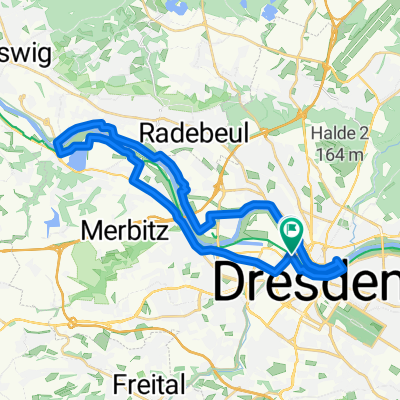
Abendfahrrunde (ohne Grundstraße)
- 56.6 km
- 290 m
- 292 m
- Dresden, Saxony, Germany
Wochenend-Tour Dresden
A cycling route starting in Dresden, Saxony, Germany.
Overview
Vom Goldenen Reiter direkt an die Elbe, ohne die Uferseite zu wechseln. Auf dem Elberadweg rechts fahren und der Beschilderung Richtung Radebeul folgen. Dort angekommen, links Richtung Schloss Wackenbarth halten. Weiter auf der Mittleren Bergstraße, dem Straßenverlauf folgen und rechts abbiegen in die Hohensteinstraße. Dem ausgeschilderten Radweg (teilweise unbefestigt) bis Schloss Moritzburg folgen. Direkt vor dem Schloss rechts abbiegen und einige Hundert Meter weiter erneut rechts auf dem Waldweg zum Fasanenschlösschen und Binnenleuchtturm. Seitlich vor dem Leuchtturm auf den Fahrradweg nach Cunnertswalde und Reichenberg. Von dort dem Lößnitzbach bis nach Radebeul folgen. In Radebeul wieder zum Elberadweg fahren. Diesmal links halten und am Fluss entlang zurück zum Reiterstandbild nach Dresden.
created this 7 years ago
Part of
Wochenend-Tour Dresden
2 stages
Route quality
Quiet road
20 km
(38 %)
Track
13.1 km
(25 %)
Paved
37.3 km
(71 %)
Unpaved
8.4 km
(16 %)
Asphalt
36.8 km
(70 %)
Gravel
4.7 km
(9 %)
Continue with Bikemap
You would like to ride Dresden: Zum Schloss Moritzburg or customize it for your own trip? Here is what you can do with this Bikemap route:
Free trial for 3 days, or one-time payment. More about Bikemap Premium.
Discover more Premium features.
Get Bikemap PremiumFrom our community
Open it in the app