

bubión - trevelez - portugos - bubión
A cycling route starting in Bubión, Andalusia, Spain.
Overview
About this route
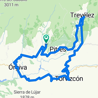
la ruta tiene el inicio al principio de la calle de la ermita para contabilizar los kilometros.
al salir de la calle de la ermita y a unos 700mts tomaremos el camino de la izquierda, para en el km 2 desviarnos a la derecha por camino principal.
a los 5 kms. tomar camino que sale a la derecha. en el km 10.5 continuar por el camino de la izquierda. antes del km 13 continuar por donde vamos. cuando se sale de trevelez continuar por la A 4132 hasta portugos pasando antes por Busquistar.una vez en portugos tomar el camino de trevelez situado mas o menos en el km 34.5 y de ahi hasta el km 39.5 donde tomaremos a la izquieda por donde hemos pasado antes. en el km. 43.2 nos desviamos a la izquierda por vereda, en el km.46 seguimos rectos y a unos 500mts continuamos por vereda para llegar a las antenas para desde ahi bajar a Bubion.
- -:--
- Duration
- 48.3 km
- Distance
- 1,295 m
- Ascent
- 1,295 m
- Descent
- ---
- Avg. speed
- ---
- Max. altitude
Continue with Bikemap
Use, edit, or download this cycling route
You would like to ride bubión - trevelez - portugos - bubión or customize it for your own trip? Here is what you can do with this Bikemap route:
Free features
- Save this route as favorite or in collections
- Copy & plan your own version of this route
- Sync your route with Garmin or Wahoo
Premium features
Free trial for 3 days, or one-time payment. More about Bikemap Premium.
- Navigate this route on iOS & Android
- Export a GPX / KML file of this route
- Create your custom printout (try it for free)
- Download this route for offline navigation
Discover more Premium features.
Get Bikemap PremiumFrom our community
Other popular routes starting in Bubión
 Alpujarra Reyes B
- Distance
- 94.2 km
- Ascent
- 1,622 m
- Descent
- 1,625 m
- Location
- Bubión, Andalusia, Spain
 DESDE PRADO DEL TORO 2
- Distance
- 48.3 km
- Ascent
- 2,029 m
- Descent
- 2,028 m
- Location
- Bubión, Andalusia, Spain
 Subida al Veleta desde Bubión
- Distance
- 35.4 km
- Ascent
- 2,090 m
- Descent
- 64 m
- Location
- Bubión, Andalusia, Spain
 Alpujarra Reyes
- Distance
- 100.8 km
- Ascent
- 1,722 m
- Descent
- 1,737 m
- Location
- Bubión, Andalusia, Spain
 bubión - trevelez - portugos - bubión
- Distance
- 48.3 km
- Ascent
- 1,295 m
- Descent
- 1,295 m
- Location
- Bubión, Andalusia, Spain
 5a pętla po górach
- Distance
- 20.6 km
- Ascent
- 623 m
- Descent
- 773 m
- Location
- Bubión, Andalusia, Spain
 Bubion-orgiva-torvizcon-trevelez-bubion
- Distance
- 83.5 km
- Ascent
- 1,697 m
- Descent
- 1,700 m
- Location
- Bubión, Andalusia, Spain
 Bubion - Refugio Poqueira
- Distance
- 24.9 km
- Ascent
- 1,379 m
- Descent
- 236 m
- Location
- Bubión, Andalusia, Spain
Open it in the app