

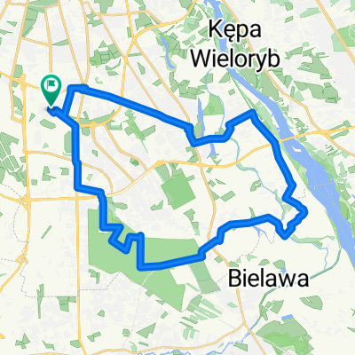
Czerniaków, Las Kabacki, Las Natoliński, Rez. Morysin, p. Wilanowska, Czerniaków
A cycling route starting in Mokotów, Masovian Voivodeship, Poland.
Overview
About this route
Czerniaków, Kabacki Forest, Natoliński Forest, Rez. Morysin, p. Wilanowska, Czerniaków
- -:--
- Duration
- 34.7 km
- Distance
- 71 m
- Ascent
- 69 m
- Descent
- ---
- Avg. speed
- ---
- Max. altitude
Continue with Bikemap
Use, edit, or download this cycling route
You would like to ride Czerniaków, Las Kabacki, Las Natoliński, Rez. Morysin, p. Wilanowska, Czerniaków or customize it for your own trip? Here is what you can do with this Bikemap route:
Free features
- Save this route as favorite or in collections
- Copy & plan your own version of this route
- Sync your route with Garmin or Wahoo
Premium features
Free trial for 3 days, or one-time payment. More about Bikemap Premium.
- Navigate this route on iOS & Android
- Export a GPX / KML file of this route
- Create your custom printout (try it for free)
- Download this route for offline navigation
Discover more Premium features.
Get Bikemap PremiumFrom our community
Other popular routes starting in Mokotów
 Konstruktorska, Warsaw to al Komisji Edukacji Narodowej, Warsaw
- Distance
- 15.9 km
- Ascent
- 61 m
- Descent
- 109 m
- Location
- Mokotów, Masovian Voivodeship, Poland
 W-wa -> Otwock -> G.Kalwaria ->Konst.->Wwa
- Distance
- 70.3 km
- Ascent
- 49 m
- Descent
- 46 m
- Location
- Mokotów, Masovian Voivodeship, Poland
 Rezerwat im. Króla Jana Sobieskiego – Zagórze – Wiązowna – Józefów
- Distance
- 60.8 km
- Ascent
- 45 m
- Descent
- 44 m
- Location
- Mokotów, Masovian Voivodeship, Poland
 just~~~~~~
- Distance
- 9.8 km
- Ascent
- 25 m
- Descent
- 19 m
- Location
- Mokotów, Masovian Voivodeship, Poland
 Służewiec - Wilanów - Okrzeszyn - Powsin - Kabaty - Służewiec. CLONED FROM ROUTE 455989
- Distance
- 35.8 km
- Ascent
- 69 m
- Descent
- 69 m
- Location
- Mokotów, Masovian Voivodeship, Poland
 gasy_obory
- Distance
- 45.2 km
- Ascent
- 44 m
- Descent
- 44 m
- Location
- Mokotów, Masovian Voivodeship, Poland
 Konstancin-Jeziorna – Góra Kalwaria – Czersk
- Distance
- 71.8 km
- Ascent
- 74 m
- Descent
- 77 m
- Location
- Mokotów, Masovian Voivodeship, Poland
 Wiązowna – Okuniew – Ossów – Kobyłka – Zielonka
- Distance
- 87.5 km
- Ascent
- 79 m
- Descent
- 79 m
- Location
- Mokotów, Masovian Voivodeship, Poland
Open it in the app