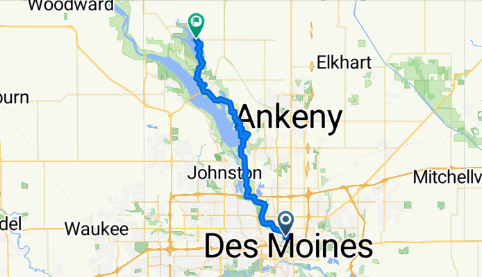
High Trestle Trail
A cycling route starting in Des Moines, Iowa, United States.
Overview
About this route
- -:--
- Duration
- 38.9 km
- Distance
- 164 m
- Ascent
- 131 m
- Descent
- ---
- Avg. speed
- ---
- Max. altitude
Route quality
Waytypes & surfaces along the route
Waytypes
Cycleway
33.1 km
(85 %)
Access road
2.3 km
(6 %)
Surfaces
Paved
32.7 km
(84 %)
Paved (undefined)
26.9 km
(69 %)
Asphalt
4.7 km
(12 %)
Route highlights
Points of interest along the route
Point of interest after 0.8 km
Established in 1892, it is one of Des Moines Oldest and original parks. It has a free children’s water play area with zero depth entry, basketball and tennis courts, two enclosed shelters, one open-air shelter, playground and the ever-popular historic rocket slide and Heritage Carousel. It also has a fully functioning wooden carousel called the Heritage Carousel ($.50 admission Open May 26th-Aug. 22nd Hours: Tue-Sun. 11am-7pm Closed Mondays!), take a walk through the Floral Garden and picnic in the shade of hundreds of trees located in the park.
Point of interest after 3.2 km
Detour: .5 mile up hill to get a great view of the river bottom. This park has a great natural playground for children and a nice pavilion too.
Photo after 4.7 km
Cool Bridge Alert
Photo after 9 km
Photo Op - Best time for images in this area is between Mid May to Late October.
Point of interest after 15.7 km
Detour half a mile to the Saylorville Dam overlooks.
Continue with Bikemap
Use, edit, or download this cycling route
You would like to ride High Trestle Trail or customize it for your own trip? Here is what you can do with this Bikemap route:
Free features
- Save this route as favorite or in collections
- Copy & plan your own version of this route
- Sync your route with Garmin or Wahoo
Premium features
Free trial for 3 days, or one-time payment. More about Bikemap Premium.
- Navigate this route on iOS & Android
- Export a GPX / KML file of this route
- Create your custom printout (try it for free)
- Download this route for offline navigation
Discover more Premium features.
Get Bikemap PremiumFrom our community
Other popular routes starting in Des Moines
- Des Moines/Gray's Lake
- Distance
- 17.3 km
- Ascent
- 302 m
- Descent
- 297 m
- Location
- Des Moines, Iowa, United States
- YEA Bike Ride
- Distance
- 14.6 km
- Ascent
- 109 m
- Descent
- 109 m
- Location
- Des Moines, Iowa, United States
- 836 E Jackson Ave, Des Moines to Pioneer Park, Des Moines
- Distance
- 15.6 km
- Ascent
- 301 m
- Descent
- 292 m
- Location
- Des Moines, Iowa, United States
- Route in Des Moines
- Distance
- 142 km
- Ascent
- 377 m
- Descent
- 377 m
- Location
- Des Moines, Iowa, United States
- Ironman Des Moines
- Distance
- 181 km
- Ascent
- 1,720 m
- Descent
- 1,723 m
- Location
- Des Moines, Iowa, United States
- 1290 Maple St, Des Moines to 1900 Saylor Rd, Des Moines
- Distance
- 3 km
- Ascent
- 3 m
- Descent
- 33 m
- Location
- Des Moines, Iowa, United States
- Confluence to Raccoon River Park
- Distance
- 12.9 km
- Ascent
- 32 m
- Descent
- 28 m
- Location
- Des Moines, Iowa, United States
- Route in Des Moines
- Distance
- 200.9 km
- Ascent
- 619 m
- Descent
- 620 m
- Location
- Des Moines, Iowa, United States
Open it in the app