
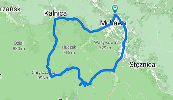
04.05.2018 Dolinka Rabe
A cycling route starting in Baligród, Subcarpathian Voivodeship, Poland.
Overview
About this route
x
- -:--
- Duration
- 27.7 km
- Distance
- 465 m
- Ascent
- 465 m
- Descent
- ---
- Avg. speed
- ---
- Max. altitude
Route quality
Waytypes & surfaces along the route
Waytypes
Track
11.6 km
(42 %)
Road
6 km
(22 %)
Surfaces
Paved
20.8 km
(75 %)
Unpaved
1.5 km
(5 %)
Asphalt
11.1 km
(40 %)
Paved (undefined)
9.7 km
(35 %)
Continue with Bikemap
Use, edit, or download this cycling route
You would like to ride 04.05.2018 Dolinka Rabe or customize it for your own trip? Here is what you can do with this Bikemap route:
Free features
- Save this route as favorite or in collections
- Copy & plan your own version of this route
- Sync your route with Garmin or Wahoo
Premium features
Free trial for 3 days, or one-time payment. More about Bikemap Premium.
- Navigate this route on iOS & Android
- Export a GPX / KML file of this route
- Create your custom printout (try it for free)
- Download this route for offline navigation
Discover more Premium features.
Get Bikemap PremiumFrom our community
Other popular routes starting in Baligród
 bieszczady_2012
- Distance
- 33 km
- Ascent
- 858 m
- Descent
- 861 m
- Location
- Baligród, Subcarpathian Voivodeship, Poland
 Bieszczady zachodnie - Wysoki Dział - Beskid Niski
- Distance
- 62.1 km
- Ascent
- 1,861 m
- Descent
- 1,861 m
- Location
- Baligród, Subcarpathian Voivodeship, Poland
 Baligród Wołkowyja kóleczko
- Distance
- 43.1 km
- Ascent
- 594 m
- Descent
- 595 m
- Location
- Baligród, Subcarpathian Voivodeship, Poland
 W koło Lipowca. Stężnica
- Distance
- 9.2 km
- Ascent
- 323 m
- Descent
- 314 m
- Location
- Baligród, Subcarpathian Voivodeship, Poland
 Bieszczady_24
- Distance
- 25.3 km
- Ascent
- 393 m
- Descent
- 413 m
- Location
- Baligród, Subcarpathian Voivodeship, Poland
 Jabłonki-Baligród-Solina-Lesko-Brzozów-Rzeszów dzień 3
- Distance
- 153.5 km
- Ascent
- 676 m
- Descent
- 1,013 m
- Location
- Baligród, Subcarpathian Voivodeship, Poland
 Chryszczata
- Distance
- 48.4 km
- Ascent
- 938 m
- Descent
- 938 m
- Location
- Baligród, Subcarpathian Voivodeship, Poland
 BIKE.TOUR.2020.1 JEZ.BOBROWE
- Distance
- 34.5 km
- Ascent
- 604 m
- Descent
- 603 m
- Location
- Baligród, Subcarpathian Voivodeship, Poland
Open it in the app