

Liberty Square 50-miler
A cycling route starting in Lexington, Massachusetts, United States.
Overview
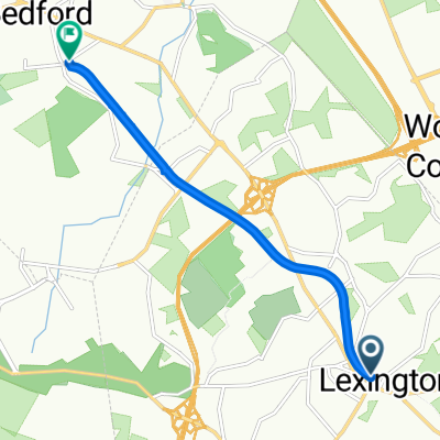
About this route
Lexington, Concord, South Acton, Stow, Boxboro, Littleton, Ayer, Forge Village, Westford, South Chelmsford, Carlisle, Bedford
- -:--
- Duration
- 85.5 km
- Distance
- 509 m
- Ascent
- 522 m
- Descent
- ---
- Avg. speed
- 143 m
- Max. altitude

Route quality
Waytypes & surfaces along the route
Waytypes
Road
40 km
(47 %)
Busy road
22.9 km
(27 %)
Surfaces
Paved
61.9 km
(72 %)
Unpaved
0.1 km
(<1 %)
Asphalt
60.9 km
(71 %)
Paved (undefined)
1 km
(1 %)
Route highlights
Points of interest along the route
Point of interest after 13.9 km
North Bridge, site of the second battle of the American Revolution
Point of interest after 31.7 km
Stow Airport: Nancy's Restaurant is excellent!
Point of interest after 39 km
Liberty Square (actually, it's a triangle)
Point of interest after 43.5 km
Bad pavement on Bruce Street, alternative is Route 110
Point of interest after 67.4 km
Great Brook Farm
Point of interest after 79.4 km
Minuteman Commuter Bikeway, Bikeway Source bike shop, Bedford Depot store
Continue with Bikemap
Use, edit, or download this cycling route
You would like to ride Liberty Square 50-miler or customize it for your own trip? Here is what you can do with this Bikemap route:
Free features
- Save this route as favorite or in collections
- Copy & plan your own version of this route
- Split it into stages to create a multi-day tour
- Sync your route with Garmin or Wahoo
Premium features
Free trial for 3 days, or one-time payment. More about Bikemap Premium.
- Navigate this route on iOS & Android
- Export a GPX / KML file of this route
- Create your custom printout (try it for free)
- Download this route for offline navigation
Discover more Premium features.
Get Bikemap PremiumFrom our community
Other popular routes starting in Lexington
 Concord-Strawberry Hill-Carlisle
- Distance
- 50.6 km
- Ascent
- 375 m
- Descent
- 374 m
- Location
- Lexington, Massachusetts, United States
 Verrill Farm Loop
- Distance
- 54 km
- Ascent
- 406 m
- Descent
- 431 m
- Location
- Lexington, Massachusetts, United States
 Minuteman Commuter Bikeway, Lexington to 74 Loomis St, Bedford
- Distance
- 6.2 km
- Ascent
- 20 m
- Descent
- 50 m
- Location
- Lexington, Massachusetts, United States
 2nd route no Stowe
- Distance
- 53.3 km
- Ascent
- 191 m
- Descent
- 194 m
- Location
- Lexington, Massachusetts, United States
 Slocum Road 31, Lexington to Massachusetts Avenue 1842, Lexington
- Distance
- 46.4 km
- Ascent
- 330 m
- Descent
- 329 m
- Location
- Lexington, Massachusetts, United States
 Dunstable Doo-Dah 70-miler
- Distance
- 108.3 km
- Ascent
- 739 m
- Descent
- 737 m
- Location
- Lexington, Massachusetts, United States
 Broadway
- Distance
- 21.7 km
- Ascent
- 121 m
- Descent
- 163 m
- Location
- Lexington, Massachusetts, United States
 26 Hancock St, Lexington to 26 Hancock St, Lexington
- Distance
- 29.3 km
- Ascent
- 90 m
- Descent
- 90 m
- Location
- Lexington, Massachusetts, United States
Open it in the app