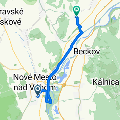
Slovakei - Tatra
A cycling route starting in Nové Mesto nad Váhom, Trenčín Region, Slovakia.
Overview
About this route
- -:--
- Duration
- 680.9 km
- Distance
- 2,223 m
- Ascent
- 2,224 m
- Descent
- ---
- Avg. speed
- ---
- Max. altitude
Route quality
Waytypes & surfaces along the route
Waytypes
Road
197.5 km
(29 %)
Quiet road
81.7 km
(12 %)
Surfaces
Paved
429 km
(63 %)
Unpaved
54.5 km
(8 %)
Asphalt
422.1 km
(62 %)
Gravel
34 km
(5 %)
Route highlights
Points of interest along the route
Point of interest after 24 km
2 Camping
Point of interest after 78.2 km
Camping - Manínska Tiesňava
Point of interest after 107.6 km
Kamping sunny rocks
Point of interest after 133.8 km
Camping Belá Nižné Kamence
Point of interest after 159.8 km
Minikemp Arrow
Point of interest after 211.6 km
2 Camping
Point of interest after 253.8 km
3 Camping
Point of interest after 279.7 km
2 Camping
Point of interest after 331 km
autocamp Tatranec
Point of interest after 333.6 km
Rijo Camping Stara Lesna
Point of interest after 383.6 km
Autocamping Vavrišovo
Point of interest after 407.8 km
MARA CAMPING
Point of interest after 416.3 km
ATC Marina Liptov
Point of interest after 504.5 km
Autocamping Neresnica
Point of interest after 528 km
Vodácke táborište Šašovské Podhradie
Point of interest after 654.5 km
Camping, Sereď
Point of interest after 661.4 km
Camping Sĺňava II
Continue with Bikemap
Use, edit, or download this cycling route
You would like to ride Slovakei - Tatra or customize it for your own trip? Here is what you can do with this Bikemap route:
Free features
- Save this route as favorite or in collections
- Copy & plan your own version of this route
- Split it into stages to create a multi-day tour
- Sync your route with Garmin or Wahoo
Premium features
Free trial for 3 days, or one-time payment. More about Bikemap Premium.
- Navigate this route on iOS & Android
- Export a GPX / KML file of this route
- Create your custom printout (try it for free)
- Download this route for offline navigation
Discover more Premium features.
Get Bikemap PremiumFrom our community
Other popular routes starting in Nové Mesto nad Váhom
- Nove Mesto nad Vahom - Myjava - Senica
- Distance
- 57.3 km
- Ascent
- 807 m
- Descent
- 797 m
- Location
- Nové Mesto nad Váhom, Trenčín Region, Slovakia
- Beckov, Kalnica do Beckov
- Distance
- 15.1 km
- Ascent
- 453 m
- Descent
- 453 m
- Location
- Nové Mesto nad Váhom, Trenčín Region, Slovakia
- NM/Vahom - Bosaca - Cachtice - NM/V
- Distance
- 70.6 km
- Ascent
- 454 m
- Descent
- 454 m
- Location
- Nové Mesto nad Váhom, Trenčín Region, Slovakia
- Trip from Nove Mesto to Piestany
- Distance
- 66.6 km
- Ascent
- 828 m
- Descent
- 855 m
- Location
- Nové Mesto nad Váhom, Trenčín Region, Slovakia
- Nové Mesto n.Váhom - Moravské Lieskové - Bzince p. Javorinou
- Distance
- 17.5 km
- Ascent
- 103 m
- Descent
- 103 m
- Location
- Nové Mesto nad Váhom, Trenčín Region, Slovakia
- Hrubá Strana, Rybníky, Dolné Srnie
- Distance
- 28.8 km
- Ascent
- 308 m
- Descent
- 308 m
- Location
- Nové Mesto nad Váhom, Trenčín Region, Slovakia
- Ulica Ondreja Plachého 156/24, Nové Mesto nad Váhom až Severná ulica 2412/38, Nové Mesto nad Váhom
- Distance
- 18.2 km
- Ascent
- 481 m
- Descent
- 480 m
- Location
- Nové Mesto nad Váhom, Trenčín Region, Slovakia
- Beckov - Inovec a späť
- Distance
- 39.2 km
- Ascent
- 951 m
- Descent
- 952 m
- Location
- Nové Mesto nad Váhom, Trenčín Region, Slovakia
Open it in the app