Moderate tour through vineyards and woods
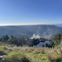
Initially leisurely, then steeper uphill, the path runs through the home of Bühler plums and climbs through the vineyards up to the ruins of Altwindeck Castle with its powerful keep and magnificent panoramic views. The ascent continues moderately until the pass height between Neusatz and Bühlertal. Passing Immenstein, forest paths lead with surprising panoramic views around the pristine upper Bühlertal. The center of Bühlertal and the Klotzberg with a wide view of the Rhine Valley and Alsace are further stops before the enjoyable descent back to Bühl.
Start
Bühl (135 m)
Coordinates:
Geographic
48.696057 N 8.129394 E
UTM
32U 435935 5394034
Destination
Bühl
Route description
Bühl - Ruins of Alt Windeck Castle
- Start of the tour at the Bühl train station. Follow Oberamthofstraße south
- After 250m, left into Oberweierer Straße to the main road, briefly right and after the traffic lights, left into Robert-Koch-Straße
- At km 1.1, at the BÜ3 fork, right toward Waldmatt onto Am Bannweg and continue straight onto Rungsstraße
- There (BÜ4, km 1.7), left and after about 400m right into Burgweg
- At the entrance of Riegel, at km 2.8, right into Kappelwindeckstraße and follow for 600m. Then right into Bühlsbergweg
- At the edge of the village of Riegel (km 3.6) half left through the vineyards and two small woods
- At km 4.6 at the entrance of Waldmatt (BÜ8), in a sharp angle to the left onto Oberen Windeckstraße uphill to the ruins of Alt Windeck Castle
Ruins of Alt Windeck Castle - Sickenwald
- There, at the BÜ9 fork, straight into the forest, at Kienzbach right following the main path to Schwarzwasen
- At km 7.9 (BT22) straight across the main road onto Kapplerwaldstraße
- At the Immenstein inn (km 8.5) into the forest. 1.6 km steadily uphill to the site "Kappler Wald". Here half-left toward Sickenwald through the barrier
- After another 1.5 km, at the "Kohlwald" site, turn left. The path now leads down continuously over the "Kohlweg" site down to Sickenwald. At the "Sickenwald" site, at km 15, in a sharp angle turn left
Sickenwald - Bühl
- At the Wiedenbach car park (km 15.1) half-right to and across the main road to Eichendorffweg, which after 500m turns into Längenbergweg at the 3-way intersection
- After another 500m, enter the Sandbuckelweg, which leads steeply down to the main road in Bühlertal
- There turn right and follow the descent to the fork (BT2), at km 17.5, near the Bühlertal town hall. Here turn left and 30m later right into Laubenstraße towards Klotzberg
- At the fork after another 300m half-left into Schützenstraße
- At km 18.7, at the BT24 fork, left onto Matthäuserstraße. Follow this 1.1 km to the vineyard gently uphill
- At the 3-way intersection, at km 19.8, left 100m uphill and at the BT23 fork turn right to Bühl into Klotzbergstraße
- Follow this for 2km downhill to Kappelwindeckstraße at the church square. Here, at km22, briefly left, then immediately right into Nelkenstraße
- After another 400m left into Schlosstraße and 200m later, at the BÜ3 fork, right back on the known path to the starting point.