

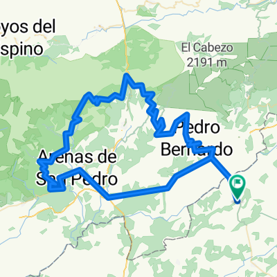
BV-Guisando-Centenera-El Sidrillo-Serranillos-PB
A cycling route starting in Buenaventura, Castille-La Mancha, Spain.
Overview
About this route
- -:--
- Duration
- 162.6 km
- Distance
- 2,460 m
- Ascent
- 2,460 m
- Descent
- ---
- Avg. speed
- ---
- Max. altitude
Route quality
Waytypes & surfaces along the route
Waytypes
Busy road
55.9 km
(34 %)
Road
42.9 km
(26 %)
Surfaces
Paved
108.3 km
(67 %)
Unpaved
11.5 km
(7 %)
Asphalt
100.1 km
(62 %)
Paved (undefined)
8.2 km
(5 %)
Continue with Bikemap
Use, edit, or download this cycling route
You would like to ride BV-Guisando-Centenera-El Sidrillo-Serranillos-PB or customize it for your own trip? Here is what you can do with this Bikemap route:
Free features
- Save this route as favorite or in collections
- Copy & plan your own version of this route
- Split it into stages to create a multi-day tour
- Sync your route with Garmin or Wahoo
Premium features
Free trial for 3 days, or one-time payment. More about Bikemap Premium.
- Navigate this route on iOS & Android
- Export a GPX / KML file of this route
- Create your custom printout (try it for free)
- Download this route for offline navigation
Discover more Premium features.
Get Bikemap PremiumFrom our community
Other popular routes starting in Buenaventura
 SG-Mijares-Serranillos-Sidrillo-Centenera-Machacona-Pedro Bernarndo
- Distance
- 154.3 km
- Ascent
- 4,606 m
- Descent
- 4,607 m
- Location
- Buenaventura, Castille-La Mancha, Spain
 Buenaventura-Centenera-El Sidrillo
- Distance
- 111.4 km
- Ascent
- 1,754 m
- Descent
- 1,754 m
- Location
- Buenaventura, Castille-La Mancha, Spain
 Pedro Bernardo-Machacona-Centenera-Serranillos-Mijares
- Distance
- 158.1 km
- Ascent
- 3,231 m
- Descent
- 3,231 m
- Location
- Buenaventura, Castille-La Mancha, Spain
 Pedro Bernardo-Sidrillo-Peña Negra-Pedro Pernardo
- Distance
- 192.2 km
- Ascent
- 3,414 m
- Descent
- 3,412 m
- Location
- Buenaventura, Castille-La Mancha, Spain
 Mijares-Navaquesera-El Pico-Pedro Bernardo
- Distance
- 126.5 km
- Ascent
- 2,482 m
- Descent
- 2,478 m
- Location
- Buenaventura, Castille-La Mancha, Spain
 Buenaventura, El Pico, Mijares
- Distance
- 127.9 km
- Ascent
- 2,276 m
- Descent
- 2,276 m
- Location
- Buenaventura, Castille-La Mancha, Spain
 Buenaventura-Guisando-Centenera-Sidrillo-Pedro Bernardo
- Distance
- 111.6 km
- Ascent
- 1,746 m
- Descent
- 1,746 m
- Location
- Buenaventura, Castille-La Mancha, Spain
 Mijares-Burgohondo-La Erilla-El Pico-Pedro Bernardo
- Distance
- 129.9 km
- Ascent
- 2,432 m
- Descent
- 2,428 m
- Location
- Buenaventura, Castille-La Mancha, Spain
Open it in the app