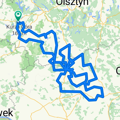
Jamielnik - Lidzbark
A cycling route starting in IĆawa, Warmian-Masurian Voivodeship, Poland.
Overview
About this route
- -:--
- Duration
- 45.9 km
- Distance
- 274 m
- Ascent
- 243 m
- Descent
- ---
- Avg. speed
- ---
- Max. altitude
Route photos
Route quality
Waytypes & surfaces along the route
Waytypes
Quiet road
23.4 km
(51 %)
Road
6.4 km
(14 %)
Surfaces
Paved
8.3 km
(18 %)
Unpaved
16.5 km
(36 %)
Gravel
8.3 km
(18 %)
Asphalt
6 km
(13 %)
Continue with Bikemap
Use, edit, or download this cycling route
You would like to ride Jamielnik - Lidzbark or customize it for your own trip? Here is what you can do with this Bikemap route:
Free features
- Save this route as favorite or in collections
- Copy & plan your own version of this route
- Sync your route with Garmin or Wahoo
Premium features
Free trial for 3 days, or one-time payment. More about Bikemap Premium.
- Navigate this route on iOS & Android
- Export a GPX / KML file of this route
- Create your custom printout (try it for free)
- Download this route for offline navigation
Discover more Premium features.
Get Bikemap PremiumFrom our community
Other popular routes starting in IĆawa
- Trasy Magiczne: zamki i paĆace nad Jeziorakiem
- Distance
- 127.6 km
- Ascent
- 221 m
- Descent
- 217 m
- Location
- IĆawa, Warmian-Masurian Voivodeship, Poland
- Ziemia Lubawska
- Distance
- 105.5 km
- Ascent
- 0 m
- Descent
- 0 m
- Location
- IĆawa, Warmian-Masurian Voivodeship, Poland
- IĆawa- Wilno
- Distance
- 494.6 km
- Ascent
- 521 m
- Descent
- 514 m
- Location
- IĆawa, Warmian-Masurian Voivodeship, Poland
- Ilawa wokol Jezioraka
- Distance
- 79.3 km
- Ascent
- 188 m
- Descent
- 185 m
- Location
- IĆawa, Warmian-Masurian Voivodeship, Poland
- ilawa ostroda pieszo
- Distance
- 91.1 km
- Ascent
- 187 m
- Descent
- 191 m
- Location
- IĆawa, Warmian-Masurian Voivodeship, Poland
- Jamielnik - Lidzbark
- Distance
- 45.9 km
- Ascent
- 274 m
- Descent
- 243 m
- Location
- IĆawa, Warmian-Masurian Voivodeship, Poland
- DOOKOĆA JEZIORAKA
- Distance
- 79.1 km
- Ascent
- 215 m
- Descent
- 216 m
- Location
- IĆawa, Warmian-Masurian Voivodeship, Poland
- Wyprawa Czerwiec 2019
- Distance
- 263.4 km
- Ascent
- 425 m
- Descent
- 410 m
- Location
- IĆawa, Warmian-Masurian Voivodeship, Poland
Open it in the app