
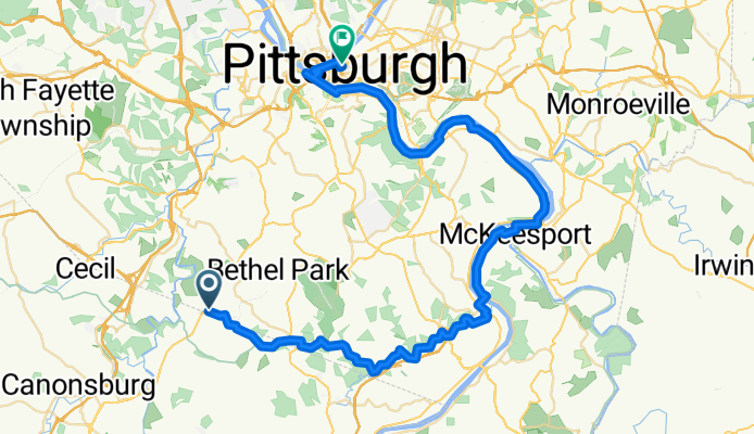
Home to Center PHG
A cycling route starting in Bryn Mawr, Pennsylvania, United States.
Overview
About this route
Ideally, take the T back to West Library
- -:--
- Duration
- 62.5 km
- Distance
- 156 m
- Ascent
- 253 m
- Descent
- ---
- Avg. speed
- ---
- Max. altitude
Route quality
Waytypes & surfaces along the route
Waytypes
Cycleway
38.1 km
(61 %)
Quiet road
12.1 km
(19 %)
Surfaces
Paved
30.3 km
(49 %)
Unpaved
9.5 km
(15 %)
Paved (undefined)
14.5 km
(23 %)
Asphalt
13.2 km
(21 %)
Continue with Bikemap
Use, edit, or download this cycling route
You would like to ride Home to Center PHG or customize it for your own trip? Here is what you can do with this Bikemap route:
Free features
- Save this route as favorite or in collections
- Copy & plan your own version of this route
- Sync your route with Garmin or Wahoo
Premium features
Free trial for 3 days, or one-time payment. More about Bikemap Premium.
- Navigate this route on iOS & Android
- Export a GPX / KML file of this route
- Create your custom printout (try it for free)
- Download this route for offline navigation
Discover more Premium features.
Get Bikemap PremiumFrom our community
Other popular routes starting in Bryn Mawr
 Highfield Court 1114, Bethel Park to Washington Road 3150, McMurray
- Distance
- 15.9 km
- Ascent
- 55 m
- Descent
- 146 m
- Location
- Bryn Mawr, Pennsylvania, United States
 Moderate route in Bethel Park
- Distance
- 24.2 km
- Ascent
- 246 m
- Descent
- 247 m
- Location
- Bryn Mawr, Pennsylvania, United States
 To Coal Valley
- Distance
- 59.7 km
- Ascent
- 624 m
- Descent
- 631 m
- Location
- Bryn Mawr, Pennsylvania, United States
 Montour Trail, Bethel Park to Montour Trail, Canonsburg
- Distance
- 12.2 km
- Ascent
- 124 m
- Descent
- 165 m
- Location
- Bryn Mawr, Pennsylvania, United States
 515 Clifton Rd, Bethel Park to 27 Klinger Rd, Canonsburg1
- Distance
- 18.2 km
- Ascent
- 246 m
- Descent
- 247 m
- Location
- Bryn Mawr, Pennsylvania, United States
 Recovered Route
- Distance
- 18.1 km
- Ascent
- 184 m
- Descent
- 251 m
- Location
- Bryn Mawr, Pennsylvania, United States
 Steady ride in Castle Shannon
- Distance
- 11.2 km
- Ascent
- 263 m
- Descent
- 299 m
- Location
- Bryn Mawr, Pennsylvania, United States
 Home to Train
- Distance
- 4.8 km
- Ascent
- 81 m
- Descent
- 78 m
- Location
- Bryn Mawr, Pennsylvania, United States
Open it in the app