

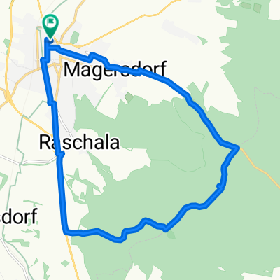
Leichte Weinviertelrunde
A cycling route starting in Hollabrunn, Lower Austria, Austria.
Overview
About this route
This is a beautiful route, especially suitable for those cyclists who feel most comfortable on flat terrain. So hop on your bike, ride the loop, and then let us know how it went for you on the route and if you liked it. I appreciate every comment.
Best regards: Author
- -:--
- Duration
- 170.9 km
- Distance
- 1,045 m
- Ascent
- 1,045 m
- Descent
- ---
- Avg. speed
- ---
- Max. altitude
Route quality
Waytypes & surfaces along the route
Waytypes
Road
68.4 km
(40 %)
Quiet road
13.7 km
(8 %)
Surfaces
Paved
46.1 km
(27 %)
Asphalt
46.1 km
(27 %)
Undefined
124.7 km
(73 %)
Continue with Bikemap
Use, edit, or download this cycling route
You would like to ride Leichte Weinviertelrunde or customize it for your own trip? Here is what you can do with this Bikemap route:
Free features
- Save this route as favorite or in collections
- Copy & plan your own version of this route
- Split it into stages to create a multi-day tour
- Sync your route with Garmin or Wahoo
Premium features
Free trial for 3 days, or one-time payment. More about Bikemap Premium.
- Navigate this route on iOS & Android
- Export a GPX / KML file of this route
- Create your custom printout (try it for free)
- Download this route for offline navigation
Discover more Premium features.
Get Bikemap PremiumFrom our community
Other popular routes starting in Hollabrunn
 HOLLABRUNN MB 3
- Distance
- 30.2 km
- Ascent
- 449 m
- Descent
- 358 m
- Location
- Hollabrunn, Lower Austria, Austria
 Samstag: Suttenbrunn-Großwetzdorf-Straning-Sitzendorf a. d. Schmida
- Distance
- 71.9 km
- Ascent
- 704 m
- Descent
- 704 m
- Location
- Hollabrunn, Lower Austria, Austria
 hollabrunn-marchegg
- Distance
- 103.4 km
- Ascent
- 385 m
- Descent
- 461 m
- Location
- Hollabrunn, Lower Austria, Austria
 Leichte Weinviertelrunde
- Distance
- 170.9 km
- Ascent
- 1,045 m
- Descent
- 1,045 m
- Location
- Hollabrunn, Lower Austria, Austria
 Freitag: Suttenbrunn - Znaim🇨🇿 - Hl. Stein -Retz - Sandberg
- Distance
- 90.9 km
- Ascent
- 884 m
- Descent
- 882 m
- Location
- Hollabrunn, Lower Austria, Austria
 Test Grünes Kreuz
- Distance
- 15.8 km
- Ascent
- 182 m
- Descent
- 180 m
- Location
- Hollabrunn, Lower Austria, Austria
 Donnerstag: Suttenbrunn - Mailberg - Alberndorf - Schöngrabern
- Distance
- 70.8 km
- Ascent
- 403 m
- Descent
- 400 m
- Location
- Hollabrunn, Lower Austria, Austria
 Abendtour
- Distance
- 27.8 km
- Ascent
- 245 m
- Descent
- 253 m
- Location
- Hollabrunn, Lower Austria, Austria
Open it in the app