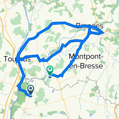
10ième etappe: Fleurville à Chalon s/Saone
A cycling route starting in Pont-de-Vaux, Auvergne-Rhône-Alpes, France.
Overview
About this route
- -:--
- Duration
- 56.8 km
- Distance
- 85 m
- Ascent
- 69 m
- Descent
- ---
- Avg. speed
- ---
- Avg. speed
Route quality
Waytypes & surfaces along the route
Waytypes
Quiet road
25.9 km
(45 %)
Path
10.9 km
(19 %)
Surfaces
Paved
14.5 km
(26 %)
Unpaved
7.6 km
(13 %)
Asphalt
13.6 km
(24 %)
Loose gravel
6.3 km
(11 %)
Continue with Bikemap
Use, edit, or download this cycling route
You would like to ride 10ième etappe: Fleurville à Chalon s/Saone or customize it for your own trip? Here is what you can do with this Bikemap route:
Free features
- Save this route as favorite or in collections
- Copy & plan your own version of this route
- Sync your route with Garmin or Wahoo
Premium features
Free trial for 3 days, or one-time payment. More about Bikemap Premium.
- Navigate this route on iOS & Android
- Export a GPX / KML file of this route
- Create your custom printout (try it for free)
- Download this route for offline navigation
Discover more Premium features.
Get Bikemap PremiumFrom our community
Other popular routes starting in Pont-de-Vaux
- Round trip Saint Benigne
- Distance
- 25.9 km
- Ascent
- 67 m
- Descent
- 65 m
- Location
- Pont-de-Vaux, Auvergne-Rhône-Alpes, France
- Le Mâconnais en VTT
- Distance
- 34 km
- Ascent
- 769 m
- Descent
- 769 m
- Location
- Pont-de-Vaux, Auvergne-Rhône-Alpes, France
- Panorama sur Cluny
- Distance
- 36.1 km
- Ascent
- 857 m
- Descent
- 860 m
- Location
- Pont-de-Vaux, Auvergne-Rhône-Alpes, France
- Steady ride in Igé
- Distance
- 19.1 km
- Ascent
- 443 m
- Descent
- 194 m
- Location
- Pont-de-Vaux, Auvergne-Rhône-Alpes, France
- 10ième etappe: Fleurville à Chalon s/Saone
- Distance
- 56.8 km
- Ascent
- 85 m
- Descent
- 69 m
- Location
- Pont-de-Vaux, Auvergne-Rhône-Alpes, France
- 70 Route de Planaise, Chavannes-sur-Reyssouze à 70 Route de Planaise, Chavannes-sur-Reyssouze
- Distance
- 20.2 km
- Ascent
- 120 m
- Descent
- 120 m
- Location
- Pont-de-Vaux, Auvergne-Rhône-Alpes, France
- avril 2014
- Distance
- 25.3 km
- Ascent
- 483 m
- Descent
- 483 m
- Location
- Pont-de-Vaux, Auvergne-Rhône-Alpes, France
- Viré-Clessé
- Distance
- 15.3 km
- Ascent
- 296 m
- Descent
- 299 m
- Location
- Pont-de-Vaux, Auvergne-Rhône-Alpes, France
Open it in the app