

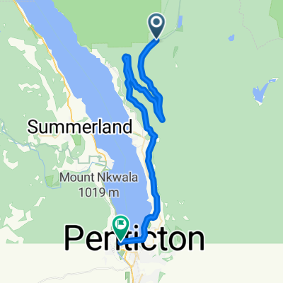
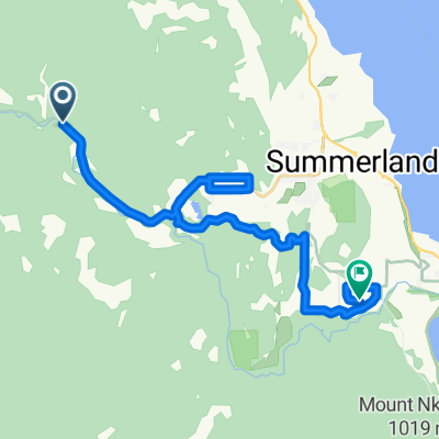
Summerland KVR TCT with notes
A cycling route starting in Summerland, British Columbia, Canada.
Overview
About this route
- -:--
- Duration
- 21.2 km
- Distance
- 291 m
- Ascent
- 479 m
- Descent
- ---
- Avg. speed
- ---
- Max. altitude

Route quality
Waytypes & surfaces along the route
Waytypes
Quiet road
11.3 km
(53 %)
Track
4.5 km
(21 %)
Surfaces
Paved
2.5 km
(12 %)
Unpaved
4.9 km
(23 %)
Gravel
4.5 km
(21 %)
Asphalt
2.5 km
(12 %)
Continue with Bikemap
Use, edit, or download this cycling route
You would like to ride Summerland KVR TCT with notes or customize it for your own trip? Here is what you can do with this Bikemap route:
Free features
- Save this route as favorite or in collections
- Copy & plan your own version of this route
- Sync your route with Garmin or Wahoo
Premium features
Free trial for 3 days, or one-time payment. More about Bikemap Premium.
- Navigate this route on iOS & Android
- Export a GPX / KML file of this route
- Create your custom printout (try it for free)
- Download this route for offline navigation
Discover more Premium features.
Get Bikemap PremiumFrom our community
Other popular routes starting in Summerland
 12-09-14 Kanada: Chute Lake Resort (Kettle Valley Rail Trail)-Penticton
- Distance
- 39.6 km
- Ascent
- 19 m
- Descent
- 819 m
- Location
- Summerland, British Columbia, Canada
 Chute Lake - Poplar Grove KVR
- Distance
- 39.1 km
- Ascent
- 71 m
- Descent
- 873 m
- Location
- Summerland, British Columbia, Canada
 KVR - Summerland to Hope
- Distance
- 250.4 km
- Ascent
- 1,095 m
- Descent
- 1,575 m
- Location
- Summerland, British Columbia, Canada
 Glenfir - Naramata - Penticton - Kaleden - OK Falls
- Distance
- 48.4 km
- Ascent
- 146 m
- Descent
- 578 m
- Location
- Summerland, British Columbia, Canada
 S - S - Bottleneck Drive - Casual
- Distance
- 29.9 km
- Ascent
- 256 m
- Descent
- 339 m
- Location
- Summerland, British Columbia, Canada
 Summerland KVR-TCT
- Distance
- 21.4 km
- Ascent
- 304 m
- Descent
- 493 m
- Location
- Summerland, British Columbia, Canada
 N - L - Naramata Loop
- Distance
- 79.1 km
- Ascent
- 1,510 m
- Descent
- 1,510 m
- Location
- Summerland, British Columbia, Canada
 N - S - Naramata Leg Warmer
- Distance
- 30.8 km
- Ascent
- 325 m
- Descent
- 325 m
- Location
- Summerland, British Columbia, Canada
Open it in the app