

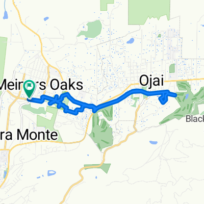
Wheeler Ojai
A cycling route starting in Meiners Oaks, California, United States.
Overview
About this route
- -:--
- Duration
- 57 km
- Distance
- 1,673 m
- Ascent
- 1,674 m
- Descent
- ---
- Avg. speed
- ---
- Max. altitude

Route quality
Waytypes & surfaces along the route
Waytypes
Track
32.5 km
(57 %)
Quiet road
2.8 km
(5 %)
Undefined
21.6 km
(38 %)
Surfaces
Paved
1.1 km
(2 %)
Asphalt
1.1 km
(2 %)
Undefined
55.8 km
(98 %)
Continue with Bikemap
Use, edit, or download this cycling route
You would like to ride Wheeler Ojai or customize it for your own trip? Here is what you can do with this Bikemap route:
Free features
- Save this route as favorite or in collections
- Copy & plan your own version of this route
- Sync your route with Garmin or Wahoo
Premium features
Free trial for 3 days, or one-time payment. More about Bikemap Premium.
- Navigate this route on iOS & Android
- Export a GPX / KML file of this route
- Create your custom printout (try it for free)
- Download this route for offline navigation
Discover more Premium features.
Get Bikemap PremiumFrom our community
Other popular routes starting in Meiners Oaks
 Ojai Valley Trail to Ojai Retreat &Inn
- Distance
- 5.4 km
- Ascent
- 30 m
- Descent
- 34 m
- Location
- Meiners Oaks, California, United States
 El Sol Avenue to El Sol Avenue
- Distance
- 12.1 km
- Ascent
- 129 m
- Descent
- 92 m
- Location
- Meiners Oaks, California, United States
 15345–15373 Maricopa Hwy, Ojai to Faria Rd, Ventura
- Distance
- 36.1 km
- Ascent
- 152 m
- Descent
- 424 m
- Location
- Meiners Oaks, California, United States
 Snail-like route in Ojai
- Distance
- 21.6 km
- Ascent
- 568 m
- Descent
- 587 m
- Location
- Meiners Oaks, California, United States
 El Sol Avenue to El Sol Avenue
- Distance
- 10.5 km
- Ascent
- 145 m
- Descent
- 104 m
- Location
- Meiners Oaks, California, United States
 Route to 163–169 W Lomita Ave, Ojai
- Distance
- 0.3 km
- Ascent
- 0 m
- Descent
- 4 m
- Location
- Meiners Oaks, California, United States
 Wheeler Ojai
- Distance
- 57 km
- Ascent
- 1,673 m
- Descent
- 1,674 m
- Location
- Meiners Oaks, California, United States
 Restful route in Ojai
- Distance
- 28 km
- Ascent
- 184 m
- Descent
- 347 m
- Location
- Meiners Oaks, California, United States
Open it in the app