

The Kill Monsanto Tour
A cycling route starting in Geneva, Canton of Geneva, Switzerland.
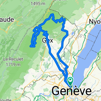
Overview
About this route
Genève-Morges et retour pour aller manifester contre Monsanto, l'infect géant américain de l'agrobusiness. Cette mobilisation citoyenne a lieu chaque année durant la 2e quinzaine de mai. En s'y rendant à vélo par le pied du Jura, on s'assure que la racaille des OGM et du glyphosate ne nous vole pas une journée. Quelques courts passages hors goudron facilement contournables pour ceux qui ont un vélo de route. Possibilité de rentrer en train si le trajet aller suffit (79 km, 750 m de D+).
LET'S KILL MON$ANTO !
Distance : 140 km
Dénivelé positif : 1070 m
Altitude maximale : 810 m (Le Vaud)
Plus d'informations sur marche-contre-monsanto.ch et www.europebybike.info
- -:--
- Duration
- 140.8 km
- Distance
- 728 m
- Ascent
- 728 m
- Descent
- ---
- Avg. speed
- ---
- Avg. speed

Route quality
Waytypes & surfaces along the route
Waytypes
Quiet road
43.6 km
(31 %)
Road
31.3 km
(22 %)
Surfaces
Paved
79.9 km
(57 %)
Unpaved
6.8 km
(5 %)
Asphalt
72.4 km
(51 %)
Paved (undefined)
5 km
(4 %)
Route highlights
Points of interest along the route
Point of interest after 79.3 km
Mon$anto de merde !
Continue with Bikemap
Use, edit, or download this cycling route
You would like to ride The Kill Monsanto Tour or customize it for your own trip? Here is what you can do with this Bikemap route:
Free features
- Save this route as favorite or in collections
- Copy & plan your own version of this route
- Split it into stages to create a multi-day tour
- Sync your route with Garmin or Wahoo
Premium features
Free trial for 3 days, or one-time payment. More about Bikemap Premium.
- Navigate this route on iOS & Android
- Export a GPX / KML file of this route
- Create your custom printout (try it for free)
- Download this route for offline navigation
Discover more Premium features.
Get Bikemap PremiumFrom our community
Other popular routes starting in Geneva
 Bords du Rhône (Petit Parcours)
- Distance
- 35.6 km
- Ascent
- 417 m
- Descent
- 417 m
- Location
- Geneva, Canton of Geneva, Switzerland
 Pas de l'Echine
- Distance
- 84.8 km
- Ascent
- 1,707 m
- Descent
- 1,705 m
- Location
- Geneva, Canton of Geneva, Switzerland
 Loop Gva-Vesancy-Vesancy-Gex-Malval
- Distance
- 77.6 km
- Ascent
- 1,029 m
- Descent
- 998 m
- Location
- Geneva, Canton of Geneva, Switzerland
 Vallée Verte Col Hunting
- Distance
- 92.6 km
- Ascent
- 1,629 m
- Descent
- 1,577 m
- Location
- Geneva, Canton of Geneva, Switzerland
 Route to Fort L'Écluse
- Distance
- 93.9 km
- Ascent
- 1,463 m
- Descent
- 1,464 m
- Location
- Geneva, Canton of Geneva, Switzerland
 25.11 WePerf
- Distance
- 72.5 km
- Ascent
- 380 m
- Descent
- 370 m
- Location
- Geneva, Canton of Geneva, Switzerland
 Two cols 110 km nice hard ride
- Distance
- 118.1 km
- Ascent
- 2,037 m
- Descent
- 2,037 m
- Location
- Geneva, Canton of Geneva, Switzerland
 Backside of the Jura, over Faucille, Marchairuz
- Distance
- 139 km
- Ascent
- 2,635 m
- Descent
- 2,595 m
- Location
- Geneva, Canton of Geneva, Switzerland
Open it in the app