

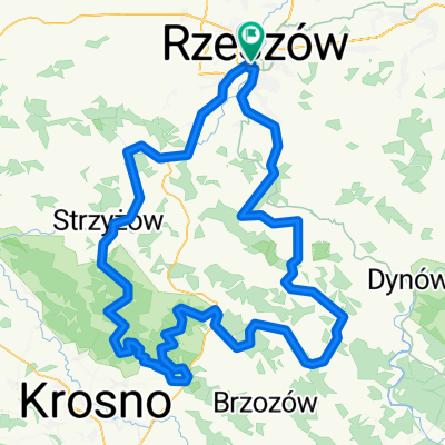
Rzeszow - Solonka (Lubenia, kladka Boguslawa)
A cycling route starting in Rzeszów, Subcarpathian Voivodeship, Poland.
Overview
About this route
Pleasant route, a steep climb to Solonka, a short rest by the springs, further climbing and then a descent through the forest towards Babica.
- -:--
- Duration
- 56.4 km
- Distance
- 271 m
- Ascent
- 272 m
- Descent
- ---
- Avg. speed
- ---
- Max. altitude

Route quality
Waytypes & surfaces along the route
Waytypes
Quiet road
19.2 km
(34 %)
Road
15.8 km
(28 %)
Surfaces
Paved
43.5 km
(77 %)
Unpaved
5.1 km
(9 %)
Asphalt
43.5 km
(77 %)
Unpaved (undefined)
2.8 km
(5 %)
Route highlights
Points of interest along the route
\"")
Photo after 26.1 km
Solonka, źródełka
\"")
Photo after 41.1 km
Continue with Bikemap
Use, edit, or download this cycling route
You would like to ride Rzeszow - Solonka (Lubenia, kladka Boguslawa) or customize it for your own trip? Here is what you can do with this Bikemap route:
Free features
- Save this route as favorite or in collections
- Copy & plan your own version of this route
- Sync your route with Garmin or Wahoo
Premium features
Free trial for 3 days, or one-time payment. More about Bikemap Premium.
- Navigate this route on iOS & Android
- Export a GPX / KML file of this route
- Create your custom printout (try it for free)
- Download this route for offline navigation
Discover more Premium features.
Get Bikemap PremiumFrom our community
Other popular routes starting in Rzeszów
 Bieszczadzka majówka
- Distance
- 274.8 km
- Ascent
- 3,568 m
- Descent
- 3,208 m
- Location
- Rzeszów, Subcarpathian Voivodeship, Poland
 Kopce Jasienickie - szkic
- Distance
- 150.4 km
- Ascent
- 1,355 m
- Descent
- 1,358 m
- Location
- Rzeszów, Subcarpathian Voivodeship, Poland
 #3 Rzeszow - Strzyzow (Zglobien, Czudec, Strzyzow, Lubenia)
- Distance
- 80.1 km
- Ascent
- 631 m
- Descent
- 632 m
- Location
- Rzeszów, Subcarpathian Voivodeship, Poland
 Rzeszów - Roch - Magdalenka - Zalesie - 26 Km
- Distance
- 26 km
- Ascent
- 295 m
- Descent
- 295 m
- Location
- Rzeszów, Subcarpathian Voivodeship, Poland
 Podjazd na Łany
- Distance
- 15.4 km
- Ascent
- 236 m
- Descent
- 233 m
- Location
- Rzeszów, Subcarpathian Voivodeship, Poland
 Mroźna wyprawa
- Distance
- 48.5 km
- Ascent
- 87 m
- Descent
- 87 m
- Location
- Rzeszów, Subcarpathian Voivodeship, Poland
 Niedzielna przejażdżka z rodziną i znajomymi
- Distance
- 59.1 km
- Ascent
- 120 m
- Descent
- 125 m
- Location
- Rzeszów, Subcarpathian Voivodeship, Poland
 RzMK 26.08.2016
- Distance
- 9.3 km
- Ascent
- 4 m
- Descent
- 16 m
- Location
- Rzeszów, Subcarpathian Voivodeship, Poland
Open it in the app