

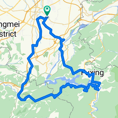
桃園至五股觀音山
A cycling route starting in Taoyuan, Taiwan, Taiwan.
Overview
About this route
- 2 h 11 min
- Duration
- 31.6 km
- Distance
- 431 m
- Ascent
- 218 m
- Descent
- 14.5 km/h
- Avg. speed
- ---
- Max. altitude

Route photos


Route quality
Waytypes & surfaces along the route
Waytypes
Road
15.2 km
(48 %)
Quiet road
4.1 km
(13 %)
Surfaces
Paved
7.3 km
(23 %)
Asphalt
7.3 km
(23 %)
Undefined
24.3 km
(77 %)
Continue with Bikemap
Use, edit, or download this cycling route
You would like to ride 桃園至五股觀音山 or customize it for your own trip? Here is what you can do with this Bikemap route:
Free features
- Save this route as favorite or in collections
- Copy & plan your own version of this route
- Sync your route with Garmin or Wahoo
Premium features
Free trial for 3 days, or one-time payment. More about Bikemap Premium.
- Navigate this route on iOS & Android
- Export a GPX / KML file of this route
- Create your custom printout (try it for free)
- Download this route for offline navigation
Discover more Premium features.
Get Bikemap PremiumFrom our community
Other popular routes starting in Taoyuan
 石門水庫環湖公路
- Distance
- 56.7 km
- Ascent
- 635 m
- Descent
- 629 m
- Location
- Taoyuan, Taiwan, Taiwan
 虎頭山環保公園
- Distance
- 5.4 km
- Ascent
- 170 m
- Descent
- 40 m
- Location
- Taoyuan, Taiwan, Taiwan
 No. 258 Tong'an St, Taoyuan District to No. 26 Tong'an St Ln 183 Aly 2, Taoyuan District
- Distance
- 15.1 km
- Ascent
- 100 m
- Descent
- 103 m
- Location
- Taoyuan, Taiwan, Taiwan
 環台完整路線
- Distance
- 1,270.9 km
- Ascent
- 1,936 m
- Descent
- 1,936 m
- Location
- Taoyuan, Taiwan, Taiwan
 桃園至五股觀音山
- Distance
- 31.6 km
- Ascent
- 431 m
- Descent
- 218 m
- Location
- Taoyuan, Taiwan, Taiwan
 ENERMAX團騎-水岸高鐵線(去程)
- Distance
- 10.6 km
- Ascent
- 73 m
- Descent
- 55 m
- Location
- Taoyuan, Taiwan, Taiwan
 家樂福-大溪-羅馬公路-關西-龍潭
- Distance
- 91.7 km
- Ascent
- 1,055 m
- Descent
- 1,058 m
- Location
- Taoyuan, Taiwan, Taiwan
 永安竹圍挑戰78KM
- Distance
- 78.1 km
- Ascent
- 190 m
- Descent
- 187 m
- Location
- Taoyuan, Taiwan, Taiwan
Open it in the app